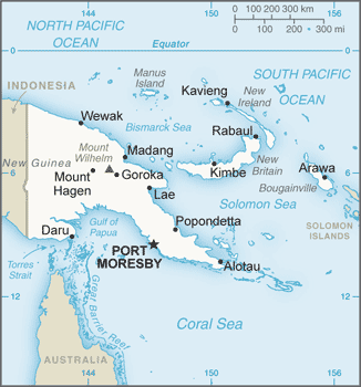
Papua New Guinea (GPS: 6 00 S, 147 00 E) located in Oceania, a group of islands including the eastern half of the island of New Guinea between the Coral Sea and the South Pacific Ocean, east of Indonesia. The country’s area measurements are total: 462,840 sq km; land: 452,860 sq km, water: 9,980 sq km. This sovereign state is slightly larger than California. The total irrigated land is 0 sq km (2012).
One of the essential features of Papua New Guinea: Shares island of New Guinea with Indonesia. Generally, east-west trending highlands break up New Guinea into diverse ecoregions. One of the world’s most extensive swamps along the southwest coast. Papua New Guinea is one of the countries along the Ring of Fire, a belt of active volcanoes and earthquake epicenters bordering the Pacific Ocean. Up to 90% of the world’s earthquakes and some 75% of the world’s volcanoes occur within the Ring of Fire.
It’s significant, and at the same time, the principal city, Port Moresby’s GPS coordinates are 9 27 S 147 11 E. Port Moresby’s local time is 15 hours ahead of Washington DC during Standard Time. The capital’s time difference: UTC+10.
Google Maps Papua New Guinea and Port Moresby, Oceania
About Papua New Guinea in detail
Flag of Papua New Guinea
Map of Papua New Guinea
The eastern half of the island of New Guinea – second largest in the world – was divided between Germany (north) and the UK (south) in 1885. The latter transferred to Australia in 1902, which occupied the northern portion during World War I and continued to administer the combined areas until independence in 1975. A nine-year secessionist revolt on the island of Bougainville ended in 1997 after claiming some 20,000 lives. Since 2001, Bougainville has experienced autonomy; A referendum asking the population if they would like independence or greater self-rule tentatively scheduled for October 2019.
Papua New Guinea’s names conventional long form: Independent State of Papua New Guinea, conventional short form: Papua New Guinea, local short form: Papuaniugini, former: Territory of Papua and New Guineaabbreviation: PNG, etymology: the word “papua” derives from the Malay “papuah” describing the frizzy hair of the Melanesians; Spanish explorer Ynigo ORTIZ de RETEZ applied the term “Nueva Guinea” to the island of New Guinea in 1545 after noting the resemblance of the locals to the peoples of the Guinea coast of Africa.
Papua New Guinea’s terrain is typically mostly mountains with coastal lowlands and rolling foothills. The country’s mean elevation: 667 m, elevation extremes; lowest point: Pacific Ocean 0 m, highest point: Mount Wilhelm 4,509 m.
The general climate in the country; tropical: northwest monsoon (December to March), southeast monsoon (May to October): slight seasonal temperature variation.
The total number of border countries is 1, Indonesia 824 km are the neighboring nations with the indicated border lengths. Papua New Guinea’s coastline is 5,152 km. Its marital claims are: measured from claimed archipelagic baselines territorial sea: 12 nautical miles, continental shelf: 200-m depth, or the depth of exploitation exclusive fishing zone: 200 nautical miles. Waterways: 11,000 km (2011). Land use: agricultural land: 2.6%; arable land 0.7%; permanent crops 1.5%; permanent pasture 0.4%; forest: 63.1%; other: 34.3% (2011 estimate).
The population in Papua New Guinea 7,027,332 (July 2018 estimate), urban population: 13% of total population (2015), central metropolitan area’s population: PORT MORESBY (capital) 345,000 (2015), while Papua New Guinea has N/A. Their spoken languages are: Tok Pisin (official language), English (official language), Hiri Motu (official language), some 836 indigenous languages spoken (about 12% of the world’s total); most languages have fewer than 1,000 speakers.
Note: Tok Pisin, a creole language, is widely used and understood; English is spoken by 1%-2%; Hiri Motu spoken by less than 2%. Main religions in Papua New Guinea are Roman Catholic 27%, Protestant 69.4% (Evangelical Lutheran 19.5%, United Church 11.5%, Seventh-Day Adventist 10%, Pentecostal 8.6%, Evangelical Alliance 5.2%, Anglican 3.2%, Baptist 2.5%, other Protestant 8.9%), Baha’i 0.3%, indigenous beliefs and other 3.3% (2000 census). The nation uses mixed legal system of English common law and customary law. It is a(n) parliamentary democracy (National Parliament) under a constitutional monarchy, a Commonwealth realm, National holiday(s) Independence Day, 16 September (1975).
Economic overview for the country: Papua New Guinea (PNG) is richly endowed with natural resources, but exploitation has been hampered by rugged terrain, land tenure issues, and the high cost of developing infrastructure. The economy has a small formal sector, focused mainly on the export of those natural resources, and an informal sector, employing most of the population.
Agriculture provides a subsistence livelihood for 85% of the people. The global financial crisis had little impact because of continued foreign demand for PNG’s commodities. Mineral deposits, including copper, gold, and oil, account for nearly two-thirds of export earnings. Natural gas reserves amount to an estimated 155 billion cubic meters. Following the construction of a $19 billion liquefied natural gas (LNG) project, PNG LNG, a consortium led by ExxonMobil, began exporting liquefied natural gas to Asian markets May 2014. The project was delivered on time and only slightly above the budget. The success of the project has encouraged other companies to look at similar LNG projects. French supermajor Total hopes to begin construction on the Papua LNG project by 2020. Due to lower global commodity prices, resource revenues of all types have fallen dramatically. PNG’s government has recently been forced to adjust spending levels downward.
Numerous challenges still face the government of Peter O’NEILL, including providing physical security for foreign investors, regaining investor confidence, restoring integrity to state institutions, promoting economic efficiency by privatizing moribund state institutions, and maintaining good relations with Australia, its former colonial ruler. Other socio-cultural challenges could upend the economy, including chronic law and order and land tenure issues. In August 2017, PNG launched its first-ever national trade policy, PNG Trade Policy 2017-2032. The policy goal is to maximize trade and investment by increasing exports, to reduce imports, and to increase foreign direct investment (FDI).
Natural resources of Papua New Guinea: gold, copper, silver, natural gas, timber, oil, fisheries.
Main export partners for Papua New Guinea, Oceania are Japan 17.4%, Australia 15.9%, China 12.1% (2015) for oil, gold, copper ore, logs, palm oil, coffee, cocoa, crayfish, prawns, while the main import partners for the country are: Australia 25.9%, China 20%, Singapore 12.6%, Malaysia 7.2%, US 4.2%, Indonesia 4.1%, South Korea 4% (2015) for machinery and transport equipment, manufactured goods, food, fuels, chemicals.
When you visit this country in Oceania, consider the natural hazards in Papua New Guinea: Active volcanism, situated along the Pacific “, Ring of Fire,” the country is subject to frequent and sometimes severe earthquakes, mudslides, tsunamis, volcanism: extreme volcanic activity, Ulawun (elevation 2,334 m), one of Papua New Guinea’s potentially most dangerous volcanoes, has been deemed a Decade Volcano by the International Association of Volcanology and Chemistry of the Earth’s Interior, worthy of study due to its tumultuous history and proximity to human populations, Rabaul (elevation 688 m) destroyed the city of Rabaul in 1937 and 1994, Lamington erupted in 1951 killing 3,000 people, Manam’s 2004 eruption forced the island’s abandonment, other historically active volcanoes include Bam, Bagana, Garbuna, Karkar, Langila, Lolobau, Long Island, Pago, St.
Andrew Strait, Victory, and Waiowa, while infectious diseases are a risk of very high food or waterborne diseases: bacterial diarrhea, hepatitis A, and typhoid fever vectorborne diseases: dengue fever and malaria. Note: active local transmission of Zika virus by Aedes species mosquitoes has been identified in this country (as of August 2016); it poses a substantial risk (a large number of cases possible) among US citizens if bitten by an infective mosquito; other less common ways to get Zika are through sex, via blood transfusion, or during pregnancy, in which the pregnant woman passes Zika virus to her fetus (2016).
Also, note that Papua New Guinea faces the following environmental issues: Rain forest loss as a result of growing commercial demand for tropical timber, unsustainable logging practices result in soil erosion, water quality degradation, and loss of habitat and biodiversity, Large-scale mining projects cause adverse impacts on forests and water quality (discharge of heavy metals, cyanide, and acids into rivers), Severe drought, Inappropriate farming practices accelerate land degradation (soil erosion, siltation, loss of soil fertility), Destructive fishing practices and coastal pollution due to run-off from land-based activities and oil spills.
You may also be interested in the countries next to Papua New Guinea around its total: 824 km border, like Indonesia.