Puerto Rico (GPS: 18 15 N, 66 30 W) is located in the Caribbean, an island between the Caribbean Sea and the North Atlantic Ocean, east of the Dominican Republic. The country’s area measurements are total: 13,791 sq km; land: 8,870 sq km, water: 4,921 sq km. This sovereign state is slightly less than three times the size of Rhode Island. The total irrigated land is 220 sq km (2012).
One of the essential features of Puerto Rico: Important location along the Mona Passage – a key shipping lane to the Panama Canal. San Juan is one of the biggest and best natural harbors in the Caribbean. Many small rivers and high central mountains ensure land is well watered. South coast relatively dry. Fertile coastal plain belt in the north.
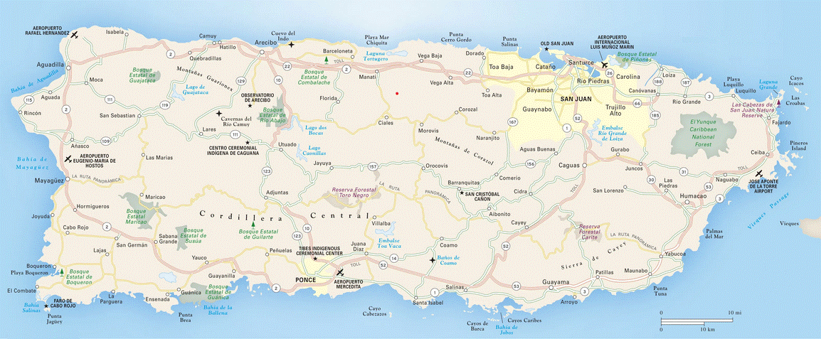
It’s significant, and at the same time, the principal city, San Juan’s GPS coordinates are 18 28 N 66 07 W. San Juan’s local time is 1 hour ahead of Washington DC during Standard Time. The capital’s time difference: UTC-4.
Google Maps Puerto Rico and San Juan, Central America and the Caribbean
About Puerto Rico in detail
Flag of Puerto Rico
Map of Puerto Rico
Populated for centuries by aboriginal peoples, the Spanish Crown claimed the island in 1493 following Christopher COLUMBUS’ second voyage to the Americas. In 1898, after 400 years of colonial rule that saw the indigenous population nearly exterminated and African slave labor introduced, Puerto Rico was ceded to the US due to the Spanish-American War. Puerto Ricans were granted US citizenship in 1917. Popularly elected governors have served since 1948. In 1952, a constitution was enacted, providing for internal self-government. In plebiscites held in 1967, 1993, and 1998, voters chose not to alter the existing political status with the US, but the results of a 2012 vote left open the possibility of American statehood.
Economic recession on the island has led to a net population loss since about 2005, as large numbers of residents moved to the US mainland. The trend has accelerated since 2010; In 2014, Puerto Rico experienced a net population loss to the mainland of 64,000, more than double the net loss of 26,000 in 2010. Hurricane Maria struck the island on 20 September 2017, causing catastrophic damage, including the destruction of the electrical grid cripled by Hurricane Irma just two weeks before. It was the worst storm to hit the island in eight decades, and the damage is estimated in the tens of billions of dollars.
Puerto Rico’s names conventional long form: Commonwealth of Puerto Rico, traditional short way: Puerto Rico, etymology: Christopher COLUMBUS named the island San Juan Bautista (Saint John the Baptist) and the capital city and main port Cuidad de Puerto Rico (Rich Port City); over time, however, the names were shortened and transposed, and the island came to be called Puerto Rico, and it’s capital San Juan. Christopher COLUMBUS named the island San Juan Bautista (Saint John the Baptist) and the capital city and main port Cuidad de Puerto Rico (Rich Port City); Over time, however, the names were shortened and transposed, and the island came to be called Puerto Rico and its capital San Juan.
Puerto Rico’s terrain is typically mountains with coastal plains in the north, precipitous cliffs to the sea on the west coast, sandy beaches, and most coastal areas. The country’s mean elevation: 261 m, elevation extremes; lowest point: the Caribbean Sea 0 m, highest point: Cerro de Punta 1,338 m.
The general climate in the country; tropical marine, mild: little seasonal temperature variation.
The total number of border countries is 0; none are the neighboring nations with the indicated border lengths. Puerto Rico’s coastline is 501 km, while its marital claims are: territorial sea: 12 nautical miles, exclusive economic zone: 200 nautical miles. Waterways: N/A. Land use: agricultural land: 22%; arable land 6.6%; permanent crops 5.6%; permanent pasture 9.8%; forest: 63.2%; other: 14.8% (2011 estimate).
The population in Puerto Rico 3,294,626 (July 2018 estimate), urban population: 93.6% of total population (2015), central metropolitan area’s population: SAN JUAN (capital) 2.463 million (2015), while Puerto Rico has population clusters tend to be found along the coast, the largest of these is found in and around San Juan; an exception to this is a sizeable population located in the interior of the island immediately south of the capital around Caguas; most of the interior, particularly in the western half of the island, is dominated by the Cordillera Central mountains, where population density is light.
Their spoken languages are Spanish, English. The main religions in Puerto Rico are Roman Catholic 85%, Protestant, and other 15%. The nation uses a civil law system based on the Spanish civil code and within the US federal system framework. It is a(n) presidential democracy; a self-governing commonwealth in political association with the US, National holiday(s) US Independence Day, 4 July (1776); Puerto Rico Constitution Day, 25 July (1952).
Economic overview for the country: Puerto Rico had one of the most dynamic economies in the Caribbean region until 2006; However, growth has been negative for the last 11 years. The downturn coincided with the phaseout of tax preferences that had led US firms to invest heavily in the Commonwealth since the 1950s and a steep rise in oil price, which generates most of the island’s electricity. Diminished job opportunities prompted a sharp rise in outmigration, as many Puerto Ricans sought jobs on the US mainland. Unemployment reached 16% in 2011 but declined to 11.5% in December 2017. US minimum wage laws apply in Puerto Rico, hampering job expansion. Per capita income is about two-thirds that of the US mainland.
The industrial sector greatly exceeds agriculture as the locus of economic activity and income. Tourism has traditionally been a significant income source with estimated arrivals of more than 3.6 million tourists in 2008. Puerto Rico’s merchandise trade surplus is robust, with exports nearly 50% greater than imports, and its current account surplus about 10% of GDP. They were closing the budget deficit while restoring economic growth and employment remain the government’s central concerns. The gap between revenues and expenditures amounted to 0.6% of GDP in 2016. However, analysts believe that not all expenses have been accounted for in the budget, and a better accounting of costs would yield an overall deficit of roughly 5% of GDP. Public debt remained steady at 92.5% of GDP in 2017, about $17,000 per person, or nearly three times the per capita debt of the State of Connecticut, the highest in the US.
Much of that debt was issued by state-run schools and public corporations, including water and electric utilities. In June 2015, Governor Alejandro GARCIA Padilla announced that the island could not pay back at least $73 billion in debt and that it would seek a deal with its creditors. Hurricane Maria hit Puerto Rico square in September 2017, causing electrical power outages to 90% of the territory, extensive loss of housing and infrastructure, and potable water contamination. Despite massive efforts, more than 40% of the region remained without electricity as of yearend 2017. As a result of the destruction, many Puerto Ricans have emigrated to the US mainland.
Natural resources of Puerto Rico: some copper and nickel; potential for onshore and offshore oil.
Main export partners for Puerto Rico, Central America, and the Caribbean are N/A for chemicals, electronics, apparel, canned tuna, rum, beverage concentrates, medical equipment, while the main import partners for the country are: N/A for chemicals, machinery, and equipment, clothing, food, fish, petroleum products.
When you visit this country in Central America and the Caribbean, consider the natural hazards in Puerto Rico: Periodic droughts, hurricanes, while infectious diseases are noted: active local transmission of Zika virus by Aedes species mosquitoes has been identified in this country (as of August 2016); it poses a significant risk (a large number of cases possible) among US citizens if bitten by an infective mosquito; other less common ways to get Zika are through sex, via blood transfusion, or during pregnancy, in which the pregnant woman passes Zika virus to her fetus (2016). Also, note that Puerto Rico faces the following environmental issues: Soil erosion, Occasional droughts that cause water shortages, Industrial pollution.
You may also be interested in the countries next to Puerto Rico around its 0 km border – No border countries.