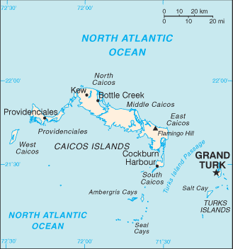
Turks and Caicos Islands (GPS: 21 45 N, 71 35 W) are located in two island groups in the North Atlantic Ocean, southeast of The Bahamas, north of Haiti. The country’s area measurements are total: 948 sq km; land: 948 sq km, water: 0 sq km. This sovereign state is 2.5 times the size of Washington, DC. The total irrigated land is 0 sq km (2012).
One of the essential features of Turks and Caicos Islands: Include eight large islands and numerous smaller cays, islets, and reefs. Only two of the Caicos Islands and six of the Turks group are inhabited.
It’s significant, and at the same time, the principal city, Grand Turk’s GPS coordinates are 21 28 N 71 08 W. Grand Turk’s local time is the same time as Washington DC during Standard Time. The capital’s time difference: UTC-5, note; Daylight saving time: +1hr begins second Sunday in March; ends first Sunday in November.
Google Maps Turks and Caicos Islands and Grand Turk, Central America and the Caribbean
About the Turks and Caicos Islands in detail
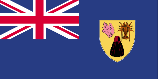
Flag of Turks and Caicos Islands
Map of Turks and Caicos Islands
The islands were part of the UK’s Jamaican colony until 1962, when they assumed a separate Crown colony upon Jamaica’s independence. The governor of The Bahamas oversaw affairs from 1965 to 1973. With Bahamian independence, the islands received a separate governor in 1973. Although independence was agreed upon for 1982, the policy was reversed, and the islands remain a British overseas territory. Grand Turk island suffered extensive damage from Hurricane Maria on 22 September 2017, resulting in loss of power and communications and damage to housing and businesses.
Turks and Caicos Islands’ names conventional long form: none, conventional short form: Turks and Caicos Islands abbreviation: TCI, etymology: the Turks Islands are named after the Turk’s cap cactus (native to the islands and appearing on the flag and coat of arms), while the Caicos Islands derive from the native term “caya hico” meaning “string of islands.” The Turks Islands are named after the Turk’s cap cactus (native to the islands and appearing on the flag and coat of arms), while the Caicos Islands derive from the native term “caya hico,” meaning “string of islands.”
Turks and Caicos Islands’ terrain is typically low, flat limestone, extensive marshes, and mangrove swamps. The country’s mean elevation: N/A, elevation extremes; lowest point: the Caribbean Sea 0 m, highest point: Flamingo Hill 48 m.
The country’s general climate is tropical: marine: moderated by trade winds: sunny and relatively dry.
The total number of border countries is 0; none are the neighboring nations with the indicated border lengths. Turks and Caicos Islands’ coastline is 389 km, while its marital claims are: territorial sea: 12 nautical miles, exclusive fishing zone: 200 nautical miles. Waterways: N/A. Land use: agricultural land: 1.1%; arable land 1.1%; permanent crops 0%; permanent pasture 0%; forest: 36.2%; other: 62.7% (2011 estimate).
The population in Turks and Caicos Islands 53,701 (July 2018 estimate), urban population: 92.2% of total population (2015), central metropolitan area’s population: GRAND TURK (capital) 5,000 (2014), while the Turks and Caicos Islands have eight of the thirty islands are inhabited; the island of Providenciales is the most populated, but the most densely populated is Grand Turk. Their spoken languages are English (official language). Main religions in the Turks and Caicos Islands are Protestant 72.8% (Baptist 35.8%, Church of God 11.7%, Anglican 10%, Methodist 9.3%, Seventh-Day Adventist 6%), Roman Catholic 11.4%, Jehovah’s Witnesses 1.8%, other 14%. The nation uses a mixed legal system of English common law and civil law. It is a(n) parliamentary democracy (House of Assembly); self-governing overseas territory of the UK, National holiday(s) Constitution Day, 30 August (1976).
Economic overview for the country: The Turks and Caicos economy is based on tourism, offshore financial services, and fishing. Most capital goods and food for domestic consumption are imported. The US is the leading source of tourists, accounting for more than three-quarters of the more than 1 million visitors that arrive annually. Three-quarters of the visitors come by ship. Significant sources of government revenue also include fees from offshore financial activities and customs receipts.
Natural resources of Turks and Caicos Islands: spiny lobster, conch.
Main export partners for Turks and Caicos Islands, Central America, and the Caribbean are N/A for lobster, dried and fresh conch, conch shells, while the main import partners for the country are: N/A for food and beverages, tobacco, clothing, manufacture, construction materials.
When you visit this country in Central America and the Caribbean, consider the natural hazards in the Turks and Caicos Islands: Frequent hurricanes, while infectious diseases are noted: active local transmission of Zika virus by Aedes species mosquitoes has been identified in this country (as of August 2016); it poses a significant risk (a large number of cases possible) among US citizens if bitten by an infective mosquito; other less common ways to get Zika are through sex, via blood transfusion, or during pregnancy, in which the pregnant woman passes Zika virus to her fetus (2016). Also, note that the Turks and Caicos Islands face the following environmental issues: Limited natural freshwater resources, private cisterns collect rainwater.
You may also be interested in the countries next to the Turks and Caicos Islands around its 0 km border – No border countries.