Bahamas (GPS: 24 15 N, 76 00 W) located in chain of islands in the North Atlantic Ocean, southeast of Florida, northeast of Cuba. The country’s area measurements are total: 13,880 sq km; land: 10,010 sq km, water: 3,870 sq km. This sovereign state is slightly smaller than Connecticut. The total irrigated land is 10 sq km (2012).
One of the important features of the Bahamas: Strategic location adjacent to the US and Cuba. The extensive island chain of which 30 are inhabited.
It’s significant, and at the same time, the principal city, Nassau’s GPS coordinates are 25 05 N 77 21 W. Nassau’s local time is the same as Washington DC during Standard Time. The capital’s time difference: UTC-5, note; Daylight saving time: +1hr begins second Sunday in March; ends first Sunday in November.
Google Maps Bahamas and Nassau, Central America and the Caribbean
About the Bahamas in detail
Flag of Bahamas
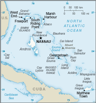
Map of Bahamas
Lucayan Indians inhabited the islands when Christopher COLUMBUS first set foot in the New World on San Salvador in 1492. British settlement of the islands began in 1647; The islands became a colony in 1783. Piracy thrived in the 17th and 18th centuries because of The Bahamas’ proximity to shipping lanes. Since attaining independence from the UK in 1973, The Bahamas has prospered through tourism, international banking, and investment management, which comprise up to 85% of GDP.
Because of its proximity to the US – the nearest Bahamian landmass being only 80 km (50 mi) from Florida – the country is a major transshipment point for illicit trafficking, particularly to the US mainland, as well as Europe. US law enforcement agencies cooperate closely with The Bahamas, and the US Coast Guard assists Bahamian authorities in coastal defense through Operation Bahamas, Turks, and Caicos, or OPBAT.
Bahamas’ names conventional long form: Commonwealth of The Bahamas, conventional short form: The Bahamas, etymology: name derives from the Spanish “Baha mar,” meaning “shallow sea,” describes the shallow waters of the Bahama Banks. The name derives from the Spanish “Baha mar,” meaning “shallow sea,” which describes the Bahama Banks’ shallow waters.
Bahamas’ terrain is typically long, flat coral formations with some low rounded hills. The country’s mean elevation: N/A, elevation extremes; lowest point: Atlantic Ocean 0 m, highest point: Mount Alvernia on Cat Island 63 m.
The general climate in the country; tropical marine: moderated by warm waters of Gulf Stream.
The total number of border countries is 0; none are the neighboring nations with the indicated border lengths. Bahamas’ coastline is 3,542 km, while its marital claims are: territorial sea: 12 nautical miles, exclusive economic zone: 200 nautical miles. Waterways: N/A. Land use: agricultural land: 1.4%; arable land 0.8%; permanent crops 0.4%; permanent pasture 0.2%; forest: 51.4%; other: 47.2% (2011 estimate).
The population in Bahamas 332,634 (July 2018 estimate), urban population: 82.9% of total population (2015), major urban area’s population: NASSAU (capital) 267,000 (2014), while the Bahamas has most of the population lives in urban areas, with two-thirds living on New Providence Island where Nassau is located. Their spoken languages are English (official language), Creole (among Haitian immigrants). Main religions in Bahamas are Protestant 69.9% (includes Baptist 34.9%, Anglican 13.7%, Pentecostal 8.9% Seventh-Day Adventist 4.4%, Methodist 3.6%, Church of God 1.9%, Brethren 1.6%), Roman Catholic 12%, other Christian 13% (includes Jehovah’s Witness 1.1%), other 0.6%, none 1.9%, unspecified 2.6% (2010 estimate). The nation uses common law system based on the English model. It is a(n) parliamentary democracy (Parliament) under a constitutional monarchy, a Commonwealth realm, National holiday(s) Independence Day, 10 July (1973).
Economic overview for the country: The Bahamas has the second-highest per capita GDP in the English-speaking Caribbean, with an economy heavily dependent on tourism and financial services. Tourism accounts for approximately 50% of GDP and directly or indirectly employs half of the archipelago’s labor force. Financial services constitute the second-most important sector of the Bahamian economy, accounting for about 15% of GDP. Manufacturing and agriculture combined contribute less than 7% of GDP and show little growth, despite government incentives aimed at those sectors.
The new government led by Prime Minister Hubert MINNIS has prioritized addressing fiscal imbalances and rising debt, which stood at 75% of GDP in 2016. Large capital projects like the Baha Mar Casino and Hotel are driving growth. Public debt increased in 2017 in large part due to hurricane reconstruction and relief financing. The primary fiscal balance was a deficit of 0.4% of GDP in 2016. The Bahamas is the only country in the Western Hemisphere that is not a member of the World Trade Organization.
Natural resources of Bahamas: salt, aragonite, timber, arable land.
Main export partners for the Bahamas, Central America, and the Caribbean are Poland 26.3%, Cote d’Ivoire 20.9%, US 15.9%, the Dominican Republic 14.3% (2015) for crawfish, aragonite, crude salt, polystyrene products, while the main import partners for the country are: the US 22.3%, China 14.8%, Japan 9.5%, Poland 7.7%, South Korea 7.3%, Colombia 6.8%, Brazil 5.6%, Singapore 5.5% (2015) for machinery and transport equipment, manufactures, chemicals, mineral fuels; food and live animals.
When you visit this country in Central America and the Caribbean, consider the natural hazards in the Bahamas: Hurricanes and other tropical storms that cause extensive flood and wind damage. At the same time, infectious diseases are N/A. Also, note that the Bahamas faces the following environmental issues: Coral reef decay, Solid waste disposal.
You may also be interested in the countries next to the Bahamas around its 0 km border – No border countries.