Armenia (GPS: 40 00 N, 45 00 E) is located in Southwestern Asia, between Turkey (to the west) and Azerbaijan; note – Armenia views itself as part of Europe; geopolitically, it can be classified as falling within Europe, the Middle East, or both. The country’s area measurements are total: 29,743 sq km; land: 28,203 sq km, water: 1,540 sq km. This sovereign state is slightly smaller than Maryland. The total irrigated land is 2,740 sq km (2012).
One of the essential features of Armenia: Landlocked in the Lesser Caucasus Mountains. Sevana Lich (Lake Sevan) is the largest lake in this mountain range.
It’s significant, and at the same time, the principal city, Yerevan’s GPS coordinates are 40 10 N 44 30 E. Yerevan’s local time is 9 hours ahead of Washington DC during Standard Time. The capital’s time difference: UTC+4.
For more information on Armenia, please scroll down below the Google Maps.
Google Maps Armenia and Yerevan, Asia
About Armenia in detail
Flag of Armenia
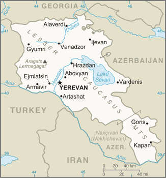
Map of Armenia
Armenia prides itself on being the first nation to adopt Christianity (early 4th century) formally. Despite periods of autonomy, over the centuries, Armenia came under various empires, including the Roman, Byzantine, Arab, Persian, and Ottoman. During World War I in the western portion of Armenia, the Ottoman Empire instituted a policy of forced resettlement coupled with other harsh practices that resulted in at least 1 million Armenian deaths. The Ottomans ceded the eastern area of Armenia to Russia in 1828; This portion declared its independence in 1918 but was conquered by the Soviet Red Army in 1920. Armenia remains involved in the protracted Nagorno-Karabakh conflict with Azerbaijan. Nagorno-Karabakh was a primarily ethnic Armenian region that Moscow recognized in 1923 as an autonomous oblast within Soviet Azerbaijan. In the late Soviet period, a separatist movement developed, which sought to end the region’s Azerbaijani control.
Fighting over Nagorno-Karabakh began in 1988 and escalated after Armenia and Azerbaijan attained independence from the Soviet Union in 1991. By the time a ceasefire took effect in May 1994, separatists, with Armenian support, controlled Nagorno‑Karabakh and seven surrounding Azerbaijani territories. The 1994 ceasefire continues to hold, although violence continues along the line of contact separating the opposing forces and the Armenia-Azerbaijan international border. The final status of Nagorno-Karabakh remains the subject of international mediation by the Organization for Security and Cooperation in Europe (OSCE) Minsk Group, which works to help the sides settle the conflict peacefully.
The OSCE Minsk Group is co‑chaired by the US, France, and Russia. Turkey closed the common border with Armenia in 1993 to support Azerbaijan in its conflict with Armenia over control of Nagorno-Karabakh and surrounding areas, further hampering Armenian economic growth. In 2009, Armenia and Turkey signed Protocols normalizing relations between the two countries, but neither government ratified the Protocols, and Armenia officially withdrew from the Protocols in March 2018. In 2015, Armenia joined the Eurasian Economic Union alongside Russia, Belarus, Kazakhstan, and Kyrgyzstan. In November 2017, Armenia signed a Comprehensive and Enhanced Partnership Agreement (CEPA) with the EU. In spring 2018, Serzh SARGSIAN of the Republican Party of Armenia (RPA) stepped down, and Civil Contract party leader Nikol PASHINYAN became prime minister.
Armenia’s names conventional long form: the Republic of Armenia, traditional short form: Armenia, local long form: Hayastani Hanrapetut’yun, local short state: Hayastan, former: Armenian Soviet Socialist Republic, Armenian Republic, etymology: the etymology of the country’s name remains obscure; according to tradition, the government is named after Hayk, the legendary patriarch of the Armenians and the great-great-grandson of Noah; Hayk’s descendant, Aram, purportedly is the source of the name Armenia. The etymology of the country’s name remains obscure; According to tradition, the country is named after Hayk, the legendary patriarch of the Armenians and the great-great-grandson of Noah; Hayk’s descendant, Aram, purportedly is the source of the name Armenia.
Armenia’s terrain is typically Armenian Highland with mountains; little forest land; fast flowing rivers; good soil in Aras River valley. The country’s mean elevation: 1,792 m, elevation extremes; lowest point: Debed River 400 m, highest point: Aragats Lerrnagagat’ 4,090 m.
The general climate in the country; highland continental, with hot summers, cold winters.
The total number of border countries is 4, Azerbaijan 996 km, Georgia 219 km, Iran 44 km, Turkey 311 km are the neighboring nations with the indicated border lengths. Armenia’s coastline is 0 km (landlocked country), while its marital claims are: none. Waterways: N/A. Land use: agricultural land: 59.7%; arable land 15.8%; permanent crops 1.9%; permanent pasture 42%; forest: 9.1%; other: 31.2% (2011 estimate).
The population in Armenia 3,038,217 (July 2018 estimate), urban population: 62.7% of total population (2015), major urban area’s population: YEREVAN (capital) 1,044 (2015), while Armenia has most of the population is located in the northern half of the country; the capital of Yerevan is home to more than three times as many people as the second-largest city in the country. Their spoken languages are Armenian (official language) 97.9%, Kurdish (spoken by Yezidi minority) 1%, other 1% (2011 estimate). Main religions in Armenia are Armenian Apostolic 92.6%, Evangelical 1%, other 2.4%, none 1.1%, unspecified 2.9% (2011 estimate). The nation uses a civil law system. It is a(n) semi-presidential republiC. Note: a constitutional referendum approved in December 2015 will change the government type to a parliamentary system, replacing the semi-presidential system and becoming effective for the 2017-18 electoral cycle, National holiday(s) Independence Day, 21 September (1991).
Economic overview for the country: Under the old Soviet central planning system, Armenia developed a modern industrial sector, supplying machine tools, textiles, and other manufactured goods to sister republics in exchange for raw materials and energy. Armenia has since switched to small-scale agriculture and away from the large agro-industrial complexes of the Soviet era. Armenia has only two open trade borders – Iran and Georgia – because its borders with Azerbaijan and Turkey have been closed since 1991 and 1993, respectively, due to Armenia’s ongoing conflict with Azerbaijan over the separatist Nagorno-Karabakh region. Armenia joined the World Trade Organization in January 2003. The government has made some tax and customs administration improvements in recent years, but anti-corruption measures have been mostly ineffective.
Armenia will need to pursue additional economic reforms and strengthen the rule of law to raise its economic growth and improve economic competitiveness and employment opportunities, especially given its economic isolation from Turkey and Azerbaijan. Armenia’s geographic isolation, a narrow export base, and pervasive monopolies in important business sectors have made it particularly vulnerable to volatility in the global commodity markets and Russia’s economic challenges. Armenia is mainly dependent on Russian commercial and governmental support, as most key Armenian infrastructure is Russian-owned and managed, especially in the energy sector. Remittances from expatriates working in Russia are equivalent to about 12-14% of GDP. Armenia joined the Russia-led Eurasian Economic Union in January 2015 but has remained interested in pursuing closer ties with the EU and signing a Comprehensive and Enhanced Partnership Agreement with the EU in November 2017. Armenia’s rising government debt leads Yerevan to tighten its fiscal policies as the amount is approaching the deficit to GDP ratio threshold set by national legislation.
Natural resources of Armenia: small deposits of gold, copper, molybdenum, zinc, bauxite.
Main export partners for Armenia, Asia are Russia 15.2%, China 11.1%, Germany 9.8%, Iraq 8.8%, Georgia 7.8%, Canada 7.6%, Bulgaria 5.3%, Iran 5.3% (2015) for pig iron, unwrought copper, nonferrous metals, gold, diamonds, mineral products, foodstuffs, energy, while the main import partners for the country are: Russia 29.1%, China 9.7%, Germany 6.2%, Iran 6.1%, Italy 4.6%, Turkey 4.2% (2015) for natural gas, petroleum, tobacco products, foodstuffs, diamonds, pharmaceuticals, cars.
When you visit this country in Asia, consider the natural hazards in Armenia: Occasionally severe earthquakes, droughts, while infectious diseases are N/A. Also, note that Armenia faces the following environmental issues: Soil pollution from toxic chemicals such as DDT, Deforestation, Pollution of Hrazdan and Aras Rivers, The draining of Sevana Lich (Lake Sevan), a result of its use as a source for hydropower, threatens drinking water supplies, Restart of Metsamor nuclear power plant despite its location in a seismically active zone.
You may also be interested in the countries next to Armenia around its total: 1,570 km border, like Azerbaijan, Georgia, Iran, Turkey.