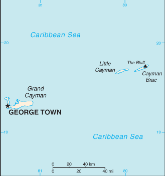
Cayman Islands (GPS: 19 30 N, 80 30 W) located in the Caribbean, three-island group (Grand Cayman, Cayman Brac, Little Cayman) in the Caribbean Sea, 240 km south of Cuba and 268 km northwest of Jamaica. The country’s area measurements are total: 264 sq km; land: 264 sq km, water: 0 sq km. This sovereign state is 1.5 times the size of Washington, DC. The total irrigated land is N/A.
One of the crucial features of the Cayman Islands: Important location between Cuba and Central America.
It’s significant, and at the same time, the principal city, George Town’s GPS coordinates are 19 18 N 81 23 W. George Town’s local time is the same time as Washington DC during Standard Time. The capital’s time difference: UTC-5, note; Daylight saving time: a decision has been made to introduce DST in the archipelago for the first time beginning in 2016; a date for implementation is pending though it seems likely it will match the date used in the US and Canada.
Google Maps Cayman Islands and George Town, Central America and the Caribbean
About the Cayman Islands in detail
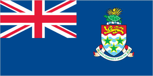
Flag of Cayman Islands
Map of Cayman Islands
The Cayman Islands were colonized from Jamaica by the British during the 18th and 19th centuries and were administered by Jamaica after 1863. In 1959, the islands became a territory within the Federation of the West Indies. When the Federation dissolved in 1962, the Cayman Islands chose to remain a British dependency. The territory has transformed itself into a significant offshore financial center.
Cayman Islands’ names conventional long form: none, conventional short form: Cayman Islands, etymology: the islands’ name comes from the native Carib word “caiman,” describing the marine crocodiles living there. The islands’ name comes from the native Carib word “caiman,” describing the marine crocodiles living there.
Cayman Islands’ terrain is typically a low-lying limestone base surrounded by coral reefs. The country’s mean elevation: N/A, elevation extremes; lowest point: the Caribbean Sea 0 m, highest point: The Bluff on Cayman Brac 43 m.
The country’s general climate is tropical marine: warm, rainy summers (May to October) and cold, relatively dry winters (November to April).
The total number of border countries is 0; none are the neighboring nations with the indicated border lengths. Cayman Islands’ coastline is 160 km, while its marital claims are: territorial sea: 12 nautical miles, exclusive fishing zone: 200 nautical miles. Waterways: N/A. Land use: agricultural land: 11.2%; arable land 0.8%; permanent crops 2.1%; permanent pasture 8.3%; forest: 52.9%; other: 35.9% (2011 estimate).
The population in Cayman Islands 59,613 (July 2018 estimate), urban population: 100% of total population (2015), major urban area’s population: GEORGE TOWN (capital) 31,000 (2014), while the Cayman Islands has the majority of the population resides on Grand Cayman. Their spoken languages are: English (official language) 90.9%, Spanish 4%, Filipino 3.3%, other 1.7%, unspecified 0.1% (2010 estimate). Main religions in Cayman Islands are Protestant 67.8% (includes Church of God 22.6%, Seventh Day Adventist 9.4%, Presbyterian/United Church 8.6%, Baptist 8.3%,Pentecostal 7.1%, non-denominational 5.3%, Anglican 4.1%, Wesleyan Holiness 2.4%), Roman Catholic 14.1%, Jehovah’s Witness 1.1%, other 7%, none 9.3%, unspecified 0.7% (2010 estimate). The nation uses English common law and local statutes. It is a(n) parliamentary democracy (Legislative Assembly); self-governing overseas territory of the UK, National holiday(s) Constitution Day, first Monday in July.
Economic overview for the country: With no direct taxation, the islands are a thriving offshore financial center. More than 65,000 companies were registered in the Cayman Islands as of 2017, including more than 280 banks, 700 insurers, and 10,500 mutual funds. A stock exchange was opened in 1997. Nearly 90% of the islands’ food and consumer goods must be imported. The Caymanians enjoy a standard of living comparable to that of Switzerland. Tourism is also a mainstay, accounting for about 70% of GDP and 75% foreign currency earnings. The tourist industry is aimed at the luxury market and caters mainly to visitors from North America. Total tourist arrivals exceeded 2.1 million in 2016, with more than three-quarters from the US.
Natural resources of Cayman Islands: fish, climate, and beaches that foster tourism.
Main export partners for the Cayman Islands, Central America, and the Caribbean are N/A for turtle products, manufactured consumer goods, while the country’s main import partners are: N/A for foodstuffs, manufactured goods, fuels.
When you visit this country in Central America and the Caribbean, consider the natural hazards in the Cayman Islands: Hurricanes (July to November), while infectious diseases are noted: active local transmission of Zika virus by Aedes species mosquitoes have been identified in this country (as of August 2016); it poses a significant risk (a large number of cases possible) among US citizens if bitten by an infective mosquito; other less common ways to get Zika are through sex, via blood transfusion, or during pregnancy, in which the pregnant woman passes Zika virus to her fetus (2016).
Also, note that the Cayman Islands faces the following environmental issues: No natural freshwater resources, Drinking water supplies are met by reverse osmosis desalination plants and rainwater catchment, Trash washing up on the beaches or being deposited there by residents, No recycling or waste treatment facilities, Deforestation (trees being cut down to create space for commercial use).
You may also be interested in the countries next to the Cayman Islands around its 0 km border – No border countries.