Cyprus (GPS: 35 00 N, 33 00 E) is located in the Middle East, an island in the Mediterranean Sea, south of Turkey; note – Cyprus views itself as part of Europe; geopolitically, it can be classified as falling within Europe, the Middle East, or both. The country’s area measurements are total: 9,251 sq km, land: 9,241 sq km, water: 10 sq km. This sovereign state is about 0.6 times the size of Connecticut. The total irrigated land is 460 sq km (2012).
One of Cyprus’s essential features is the third largest island in the Mediterranean Sea (after Sicily and Sardinia). Several small Cypriot enclaves exist within the Dhekelia Sovereign Base Area.
It’s significant, and at the same time, the principal city, Nicosia’s GPS coordinates are 35 10 N 33 22 E. Nicosia’s local time is 7 hours ahead of Washington DC during Standard Time. The capital’s time difference: UTC+2, note; Daylight saving time: +1hr begins last Sunday in March; ends last Sunday in October.
For more information on Cyprus, please scroll down below the Google Maps.
Google Maps Cyprus and Nicosia, Middle East
About Cyprus in detail
Flag of Cyprus
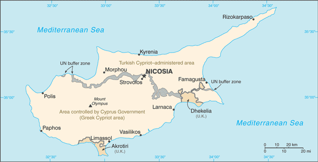
Map of Cyprus
A former British colony, Cyprus became independent in 1960 following years of resistance to British rule. Tensions between the Greek Cypriot majority and Turkish Cypriot minority communities came to a head in December 1963, when violence broke out in Nicosia’s capital. Despite UN peacekeepers’ deployment in 1964, sporadic intercommunal violence continued, forcing most Turkish Cypriots into enclaves throughout the island. In 1974, a Greek Government-sponsored attempt to overthrow Cyprus’s elected president was met by military intervention from Turkey, which soon controlled more than a third of the island. In 1983, the Turkish Cypriot administered area declared itself the “Turkish Republic of Northern Cyprus” (“TRNC”), but it is recognized only by Turkey. An UN-mediated agreement, the Annan Plan, failed to win approval by both communities in 2004.
In February 2014, after a hiatus of nearly two years, the two communities’ leaders resumed formal discussions under UN auspices aimed at reuniting the divided island. The most recent negotiations to reunify the island were suspended in July 2017 after failing to achieve a breakthrough. The entire island entered the EU on 1 May 2004. However, the EU acquis – the body of common rights and obligations – applies only to the areas under the internationally recognized government and is suspended in the “TRNC.” However, individual Turkish Cypriots able to document their eligibility for the Republic of Cyprus citizenship legally enjoy the same rights accorded to other EU states’ citizens.
Cyprus’s names conventional long form: the Republic of Cyprus, traditional short form: Cyprus, local long form: Kypriaki Dimokratia/Kibris Cumhuriyeti, local short state: Kypros/Kibris. Note: the Turkish Cypriot community, which administers the northern part of the island, refers to itself as the “Turkish Republic of Northern Cyprus” or “TRNC” (“Kuzey Kibris Turk Cumhuriyeti” or “KKTC”), etymology: the derivation of the name “Cyprus” is unknown, but the extensive mining of copper metal on the island in antiquity gave rise to the Latin word “cuprum” for copper. The derivation of the name “Cyprus” is unknown, but the extensive mining of copper metal on the island in antiquity gave rise to the Latin word “cuprum” for copper.
Cyprus’s terrain is typically a central plain with mountains to north and south; scattered but significant plains along the southern coast. The country’s mean elevation: 91 m, elevation extremes; lowest point: the Mediterranean Sea 0 m, highest point: Mount Olympus 1,951 m.
The country’s general climate is temperate: The Mediterranean with hot, dry summers and cold winters.
The total number of border countries is 2; Border sovereign base areas: Akrotiri 48 km, Dhekelia 108 km are the neighboring nations with the indicated border lengths. Cyprus’s coastline is 648 km, while its marital claims are: territorial sea: 12 nautical miles, contiguous zone: 24 nautical miles, continental shelf: 200-m depth or to the depth of exploitation. Waterways: N/A. Land use: agricultural land: 13.4%; arable land 9.8%; permanent crops 3.2%; permanent pasture 0.4%; forest: 18.8%; other: 67.8% (2011 estimate).
The population in Cyprus 1,237,088 (July 2018 estimate), urban population: 66.9% of total population (2015), major urban area’s population: NICOSIA (capital) 251,000 (2014), while Cyprus has a population concentrated in central Nicosia and the major cities of the south: Paphos, Limassol, and Larnaca. Their spoken languages are: Greek (official language) 80.9%, Turkish (official language) 0.2%, English 4.1%, Romanian 2.9%, Russian 2.5%, Bulgarian 2.2%, Arabic 1.2%, Filipino 1.1%, other 4.3%, unspecified 0.6%. Note: data represent only the government-controlled area of Cyprus (2011 estimate). Main religions in Cyprus are Orthodox Christian 89.1%, Roman Catholic 2.9%, Protestant/Anglican 2%, Muslim 1.8%, Buddhist 1%, other (includes Maronite, Armenian Church, Hindu) 1.4%, unknown 1.1%, none/atheist 0.6%note: data represent only the government-controlled area of Cyprus (2011 estimate).
The nation uses a mixed legal system of English common law and civil law with European law supremacy. It is a(n) Republic of Cyprus – presidential democracy; Turkish Republic of Northern Cyprus (self-declared) – semi-presidential democracy. Note: a separation of the two central ethnic communities inhabiting the island began following the outbreak of communal strife in 1963; this separation was further solidified when a Greek military-junta-supported coup attempt prompted the Turkish intervention in July 1974 that gave the Turkish Cypriots de facto control in the north; Greek Cypriots control the only internationally recognized government on the island; on 15 November 1983, then Turkish Cypriot “President” Rauf DENKTAS declared independence and the formation of a “Turkish Republic of Northern Cyprus” (“TRNC”), which is recognized only by Turkey, National holiday(s) Independence Day, 1 October (1960).
Economic overview for the country: The area of the Republic of Cyprus under government control has a market economy dominated by a services sector that accounts for more than four-fifths of GDP. Tourism, finance, shipping, and real estate have traditionally been the most critical services. Cyprus has been a member of the EU since May 2004 and adopted the euro as its national currency in January 2008. During the first five years of EU membership, the Cyprus economy grew at an average rate of about 4%, with unemployment between 2004 and 2008 averaging about 4%. However, the economy tipped into recession in 2009. The ongoing global financial crisis and low demand hit the tourism and construction sectors—an overextended banking sector with excessive exposure to Greek debt added to the contraction.
Cyprus’s biggest two banks were among the most extensive Greek bonds holders in Europe and had a substantial presence in Greece through bank branches and subsidiaries. Following numerous downgrades of its credit rating, Cyprus lost access to international capital markets in May 2011. In July 2012, Cyprus became the fifth euro-zone government to request an economic bailout program from the European Commission, European Central Bank, and the International Monetary Fund – known collectively as the “Troika.” Shortly after the election of President Nikos ANASTASIADES in February 2013, Cyprus reached an agreement with the Troika on a $13 billion bailout that triggered a two-week bank closure and the imposition of capital controls that remained partially in place until April 2015. Cyprus’s two largest banks merged, and the combined entity was recapitalized through conversion of some large bank deposits to shares and imposition of losses on bank bondholders.
As with other EU countries, the Troika conditioned the bailout to pass financial and structural reforms and privatize state-owned enterprises. Despite downsizing and restructuring, the Cypriot financial sector remains burdened by the most extensive stock of non-performing loans in the eurozone, equal to nearly half of all loans. Since the bailout, Cyprus has received positive appraisals by the Troika and outperformed fiscal targets but has struggled to overcome political opposition to bailout-mandated legislation, particularly regarding privatizations. The rate of non-performing loans (NPLs) is still very high at around 49%, and growth would accelerate if Cypriot banks could increase the pace of resolution of the NPLs. In October 2013, a US-Israeli consortium completed preliminary appraisals of hydrocarbon deposits in Cyprus’ exclusive economic zone (EEZ), which estimated gross mean reserves of about 130 billion cubic meters. Though exploration continues in Cyprus’ EEZ, no additional commercially exploitable reserves have been identified. Developing offshore hydrocarbon resources remains a critical component of the government’s economic recovery efforts, but development has been delayed due to regional developments and disagreements about exploitation methods.
Main export partners for Cyprus, Middle East are Greece 10.9%, Ireland 10.2%, UK 7.2%, Israel 6% (2015) for citrus, potatoes, pharmaceuticals, cement, clothing, while the main import partners for the country are: Greece 25.7%, UK 9.1%, Italy 8%, Germany 7.5%, Israel 5.5%, China 4.8%, Netherlands 4.1% (2015) for consumer goods, petroleum and lubricants, machinery, transport equipment.
When you visit this country in the Middle East, consider the natural hazards in Cyprus: Moderate earthquake activity, droughts, while infectious diseases are N/A. Also, note that Cyprus faces the following environmental issues: Water resource problems (no natural reservoir catchments, the seasonal disparity in rainfall, seawater intrusion to the island’s largest aquifer, increased salination in the north), water pollution from sewage, industrial wastes, and pesticides, Coastal degradation, Erosion, Loss of wildlife habitats from urbanization.
You may also be interested in the countries next to Cyprus around its total: 156 km border, like Akrotiri, Dhekelia.