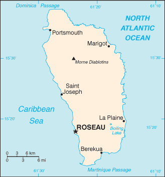
Dominica (GPS: 15 25 N, 61 20 W) is located in the Caribbean, an island between the Caribbean Sea and the North Atlantic Ocean, about halfway between Puerto Rico and Trinidad and Tobago. The country’s area measurements are total: 751 sq km; land: 751 sq km, water: 0 sq km. This sovereign state is slightly more than four times the size of Washington, DC. The total irrigated land is N/A.
One of the essential features of Dominica: Known as “The Nature Island of the Caribbean” due to its spectacular, lush, and varied flora and fauna, which are protected by an extensive natural park system. The most mountainous of the Lesser Antilles, its volcanic peaks are cones of lava craters and include Boiling Lake, the second-largest, thermally active lake in the world.
It’s significant, and at the same time, the principal city, Roseau’s GPS coordinates are 15 18 N 61 24 W. Roseau’s local time is 1 hour ahead of Washington DC during Standard Time. The capital’s time difference: UTC-4.
Google Maps Dominica and Roseau, Central America and the Caribbean
About Dominica in detail
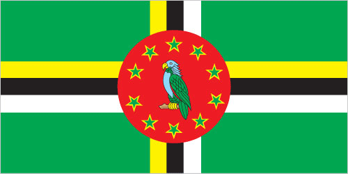
Flag of Dominica
Map of Dominica
Dominica was the last of the Caribbean islands to be colonized by Europeans due chiefly to the fierce resistance of the native Caribs. France ceded possession to Great Britain in 1763, which colonized the island in 1805. Slavery ended in 1833, and in 1835 the first three men of African descent were elected to the legislative assembly of Dominica. In 1871, Dominica became part first of the British Leeward Islands and then the British Windward Islands until 1958.
In 1967 Dominica became an associated state of the UK and formally took responsibility for its internal affairs. In 1980, two years after independence, Dominica’s fortunes improved when a corrupt and tyrannical administration was replaced by Mary Eugenia CHARLES, the first female prime minister in the Caribbean, who remained in office for 15 years. On 18 September 2017, Hurricane Maria passed over the island, causing extensive damage to structures, roads, communications, and the power supply, and largely destroying critical agricultural areas.
Dominica’s names conventional long form: Commonwealth of Dominica, traditional short state: Dominica, etymology: explorer Christopher COLUMBUS named the island for the day of the week on which he spotted it, Sunday (“Domingo” in Latin), 3 November 1493. Explorer Christopher COLUMBUS named the island for the day of the week on which he spotted it, Sunday (“Domingo” in Latin), 3 November 1493.
Dominica’s terrain is typically rugged mountains of volcanic origin. The country’s mean elevation: N/A, elevation extremes; lowest point: the Caribbean Sea 0 m, highest point: Morne Diablotins 1,447 m.
The general climate in the country; tropical: moderated by northeast trade winds: heavy rainfall.
The total number of border countries is 0; none are the neighboring nations with the indicated border lengths. Dominica’s coastline is 148 km, while its marital claims are: territorial sea: 12 nautical miles, contiguous zone: 24 nautical miles, exclusive economic zone: 200 nautical miles. Waterways: N/A. Land use: agricultural land: 34.7%; arable land 8%; permanent crops 24%; permanent pasture 2.7%; forest: 59.2%; other: 6.1% (2011 estimate).
The population in Dominica 74,027 (July 2018 estimate), urban population: 69.5% of total population (2015), major urban area’s population: ROSEAU (capital) 15,000 (2014), while Dominica has a population is mostly clustered along the coast, with roughly a third living in the parish of St. George, in or around the capital of Roseau; the volcanic interior is sparsely populated. Their spoken languages are English (official language), French patois. Main religions in Dominica are Roman Catholic 61.4%, Protestant 28.6% (includes Evangelical 6.7%, Seventh Day Adventist 6.1%, Pentecostal 5.6%, Baptist 4.1%, Methodist 3.7%, Church of God 1.2%, other 1.2%), Rastafarian 1.3%, Jehovah’s Witness 1.2%, other 0.3%, none 6.1%, unspecified 1.1% (2001 estimate). The nation uses common law based on the English model. It is a(n) parliamentary republic, National holiday(s) Emancipation Day (First Monday), celebrated on first Monday in August (1834); Independence Day, 3 November (1978).
Economic overview for the country: The Dominican economy depended on agriculture – primarily bananas – in years past, but increasingly has been driven by tourism, as the government seeks to promote Dominica as an “ecotourism” destination. However, Hurricane Maria, which passed through the island in September 2017, destroyed much of the country’s agricultural sector and caused damage to all of the country’s transportation and physical infrastructure.
Before Hurricane Maria, the government had attempted to foster an offshore financial industry and planned to sign agreements with the private sector to develop geothermal energy resources. When government finances are fragile, the government’s focus has been to get the country back in shape to service cruise ships. The economy contracted in 2015 and recovered to positive growth in 2016 due to a recovery of agriculture and tourism. Dominica suffers from high debt levels, which increased from 67% of GDP in 2010 to 77% in 2016. Dominica is one of five countries in the East Caribbean with citizenship by investment programs whereby foreigners can obtain passports for a fee, and revenue from this contributes to government budgets.
Natural resources of Dominica: timber, hydropower, arable land.
Main export partners for Dominica, Central America, and the Caribbean are Japan 38.1%, Jamaica 19%, Antigua and Barbuda 10.4%, Trinidad and Tobago 6.2%, St. Lucia 4.8%, St. Kitts and Nevis 4.2% (2015) for bananas, soap, bay oil, vegetables, grapefruit, oranges, while the main import partners for the country are: Japan 42%, Trinidad and Tobago 17%, US 11.9%, China 6% (2015) for manufactured goods, machinery and equipment, food, chemicals.
When you visit this country in Central America and the Caribbean, consider the natural hazards in Dominica: Flash floods are a constant threat, destructive hurricanes can be expected during the late summer months, while infectious diseases are noted: active local transmission of Zika virus by Aedes species mosquitoes has been identified in this country (as of August 2016); it poses a significant risk (a large number of cases possible) among US citizens if bitten by an infective mosquito; other less common ways to get Zika are through sex, via blood transfusion, or during pregnancy, in which the pregnant woman passes Zika virus to her fetus (2016). Also, note that Dominica faces the following environmental issues: Water shortages a continuing concern, Pollution from agrochemicals and untreated sewage, Forests endangered by the expansion of farming, Soil erosion, Pollution of the coastal zone by agricultural and industrial chemicals, and untreated sewage.
You may also be interested in the countries next to Dominica around its 0 km border – No border countries.