Palau (GPS: 7 30 N, 134 30 E) is located in Oceania, an island in the North Pacific Ocean, southeast of the Philippines. The country’s area measurements are total: 459 sq km; land: 459 sq km, water: 0 sq km. This sovereign state is slightly more than 2.5 times the size of Washington, DC. The total irrigated land is 0 sq km (2012).
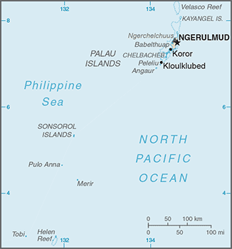
Palau’s essential features: the Westernmost archipelago in the Caroline chain, which consists of six island groups totaling more than 300 islands. Includes World War II battleground of Beliliou (Peleliu) and world-famous Rock Islands.
It’s significant, and at the same time, the principal city, Ngerulmud’s GPS coordinates are 7 30 N 134 37 E. Ngerulmud’s local time is 14 hours ahead of Washington DC during Standard Time. The capital’s time difference: UTC+9.
For more information on Palau, please scroll down below the Google Maps.
Google Maps Palau and Ngerulmud, Oceania
About Palau in detail
Flag of Palau
Map of Palau
After three decades as part of the UN Trust Territory of the Pacific under US administration, this westernmost cluster of the Caroline Islands opted for independence in 1978 rather than join the Federated States of Micronesia. A Compact of Free Association with the US was approved in 1986 but not ratified until 1993. It entered into force the following year when the islands gained independence.
Palau’s names conventional long form: the Republic of Palau, traditional short form: Palau, local long form: Beluu er a Belau, local short form: Belau, former: Trust Territory of the Pacific Islands, Palau District, etymology: from the Palauan name for the islands, Belau, which likely derives from the Palauan word “beluu” meaning “village.”
Palau’s terrain is typically varying topography from the high, mountainous main island of Babelthuap to low, coral islands usually fringed by extensive barrier reefs. The country’s mean elevation: N/A, elevation extremes; lowest point: Pacific Ocean 0 m, highest point: Mount Ngerchelchuus 242 m.
The country’s general climate is tropical: hot and humid: wet season May to November.
The total number of border countries is 0; none are the neighboring nations with the indicated border lengths. Palau’s coastline is 1,519 km, while its marital claims are: territorial sea: 3 nautical miles, exclusive fishing zone: 200 nautical miles. Waterways: N/A. Land use: agricultural land: 10.8%; arable land 2.2%; permanent crops 4.3%; permanent pasture 4.3%; forest: 87.6%; other: 1.6% (2011 estimate).
The population in Palau 21,516 (July 2018 estimate), urban population: 87.1% of total population (2015), major urban area’s population: MELEKEOK (capital) 299 (2012), while Palau has N/A. Their spoken languages are: Palauan (official language on most islands) 66.6%, Carolinian 0.7%, other Micronesian 0.7%, English (official language) 15.5%, Filipino 10.8%, Chinese 1.8%, other Asian 2.6%, other 1.3%. Note Sonsoral (Sonsoralese and English are official languages), Tobi (Tobi and English are official languages), and Angaur (Angaur, Japanese, and English are official languages) (2005 estimate). Main religions in Palau are Roman Catholic 49.4%, Protestant 30.9% (includes Protestant (general) 23.1%, Seventh Day Adventist 5.3%, and other Protestant 2.5%), Modekngei 8.7% (indigenous to Palau), Jehovah’s Witnesses 1.1%, other 8.8%, none or unspecified 1.1% (2005 estimate).
The nation uses a mixed legal system of civil, common, and customary law. It is a(n) presidential republic in free association with the US, National holiday(s) Constitution Day, 9 July (1981), day of a national referendum to pass the new constitution; Independence Day, 1 October (1994).
Economic overview for the country: The economy is dominated by tourism, fishing, and subsistence agriculture. Government is a significant employer of the workforce relying on financial assistance from the US under the Compact of Free Association (Compact) with the US that took effect after the end of the UN trusteeship on 1 October 1994. The US provided Palau with roughly $700 million in aid for the first 15 years following the Compact’s commencement in 1994 in return for unrestricted access to its land and waterways for strategic purposes. The population enjoys a per capita income roughly double that of the Philippines and much of Micronesia.
Business and leisure tourist arrivals reached a record 167,966 in 2015, a 14.4% increase over the previous year, but fell to 138,408 in 2016. Long-run prospects for tourism have been bolstered by the expansion of air travel in the Pacific, the rising prosperity of industrial East Asia, and foreigners’ willingness to finance infrastructure development. Proximity to Guam, the region’s primary destination for tourists from East Asia, and a regionally competitive tourist infrastructure enhance Palau’s advantage as a destination.
Main export partners for Palau, Oceania are N/A for shellfish, tuna, copra, garments, while the main import partners for the country are: N/A for machinery and equipment, fuels, metals, foodstuffs.
When you visit this country in Oceania, consider the natural hazards in Palau: Typhoons (June to December), while infectious diseases are N/A. Also, note that Palau faces the following environmental issues: Inadequate facilities for disposal of solid waste, Threats to the marine ecosystem from sand and coral dredging, illegal and destructive fishing practices, and overfishing. Climate change contributes to rising sea-level and coral bleaching, Drought.
You may also be interested in Palau’s surrounding countries around its 0 km border – No border countries.