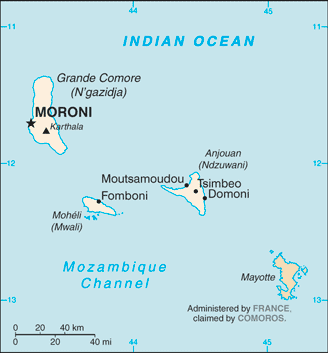
Comoros (GPS: 12 10 S, 44 15 E) is located in Southern Africa, a group of islands at the northern mouth of the Mozambique Channel, about two-thirds of the way between northern Madagascar and northern Mozambique. The country’s area measurements are total: 2,235 sq km; land: 2,235 sq km, water: 0 sq km. This sovereign state is slightly more than 12 times the size of Washington, DC. The total irrigated land is 1.3 sq km (2012).
One of the crucial features of Comoros: Important location at the northern end of Mozambique Channel.
It’s significant, and at the same time, the principal city, Moroni’s GPS coordinates are 11 42 S 43 14 E. Moroni’s local time is 8 hours ahead of Washington DC during Standard Time. The capital’s time difference: UTC+3.
For more information on Comoros, please scroll down below the Google Maps.
Google Maps Comoros and Moroni, Africa
About Comoros in detail
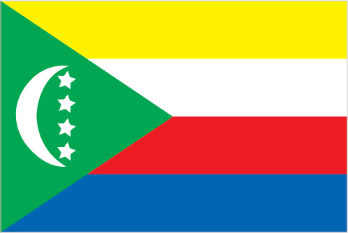
Flag of Comoros
Map of Comoros
The archipelago of Comoros in the Indian Ocean, composed of Mayotte, Anjouan, Moheli, and Grande Comore, declared independence from France on 6 July 1975. Residents of Mayotte voted to remain in France, and France now has classified it as a France department. Since independence, Comoros has endured political instability through realized and attempted coups. In 1997, the islands of Anjouan and Moheli declared independence from Comoros. In 1999, military chief Col. AZALI Assoumani seized power of the entire government in a bloodless coup; He initiated the 2000 Fomboni Accords, a power-sharing agreement in which the federal presidency rotates among the three islands, and each island maintains its local government. AZALI won the 2002 federal presidential election as president of the Union of Comoros from Grande Comore Island, which held the first four-year term. AZALI stepped down in 2006, and President Ahmed Abdallah Mohamed SAMBI was elected to office as president from Anjouan.
In 2007, Mohamed BACAR effected Anjouan’s de-facto secession from the Union of Comoros, refusing to step down when Comoro’s other islands held legitimate elections in July. The African Union (AU) initially attempted to resolve the political crisis by applying sanctions and a naval blockade to Anjouan. Still, in March 2008, the AU and Comoran soldiers seized the island. The island’s inhabitants generally welcomed the move. In 2009, the Comorian population approved a constitutional referendum extending the president’s term from four years to five years.
In May 2011, Ikililou DHOININE won the presidency in peaceful elections widely deemed free and fair. In closely contested elections in 2016, former President AZALI Assoumani won a second term when the rotating presidency returned to Grande Comore. A new constitution was passed in July 2018, which allowed for two consecutive five-year presidential terms and abolished the island-specific vice presidents. Under the new constitution, the incumbent president can run for a second term against candidates from the next island in line for the rotation. In August 2018, President AZALI formed a new government and subsequently ran and was elected president in March 2019.
Comoros’s names conventional long form: Union of Comoros, traditional short way: Comoros, local extended state: Udzima wa Komori (Comorian); Union des Comores (French); Jumhuriyat al Qamar al Muttahidah (Arabic), local short form: Komori (Comorian); Comores (French); Juzur al Qamar (Arabic), etymology: name derives from the Arabic designation “Juzur al Qamar” meaning “Islands of the Moon.” The name derives from the Arabic designation “Juzur al Qamar,” meaning “Islands of the Moon.”
Comoros’s terrain is typically volcanic islands; interiors vary from steep mountains to low hills. The country’s mean elevation: N/A, elevation extremes; lowest point: Indian Ocean 0 m, highest point: Karthala 2,360 m.
The general climate in the country; tropical marine: rainy season (November to May).
The total number of border countries is 0; none are the neighboring nations with the indicated border lengths. Comoros’s coastline is 340 km, while its marital claims are: territorial sea: 12 nautical miles, exclusive economic zone: 200 nautical miles. Waterways: N/A. Land use: agricultural land: 84.4%; arable land 46.7%; permanent crops 29.6%; permanent pasture 8.1%; forest: 1.4%; other: 14.2% (2011 estimate).
The population in Comoros 821,164 (July 2018 estimate), urban population: 28.3% of total population (2015), central metropolitan area’s population: MORONI (capital) 56,000 (2014), while Comoros has N/A. Their spoken languages are Arabic (official language), French (official language), Shikomoro (official language; a blend of Swahili, and Arabic) (Comorian). Comoros’s main religions are Sunni Muslim 98%, Roman Catholic 2%note: Islam is the state religion. The nation uses a mixed legal system of Islamic religious law, the French civil code of 1975, and customary law. It is a(n) federal presidential republic, National holiday(s) Independence Day, 6 July (1975).
Economic overview for the country: One of the world’s lowest and smallest economies, Comoros, comprises three islands hampered by inadequate transportation links, a young and rapidly increasing population, and few natural resources. The labor force’s low educational level contributes to a subsistence level of economic activity and a heavy dependence on foreign grants and technical assistance. Agriculture, including fishing, hunting, and forestry, accounts for about 50% of GDP, employs a majority of the labor force, and provides most exports. Export income is heavily reliant on the three main crops of vanilla, cloves, and ylang-ylang (perfume essence); And Comoros’ export earnings are easily disrupted by disasters such as extreme weather. Despite agriculture’s importance to the economy, the country imports roughly 70% of its food; Rice, the main staple, and other dried vegetables account for more than 25% of imports.
Remittances from about 300,000 Comorans contribute about 25% of the country’s GDP. France, Comoros’s colonial power, remains a crucial trading partner and bilateral donor. Comoros faces an education system in need of upgrades, limited opportunities for private commercial and industrial enterprises, low health services, limited exports, and a high population growth rate. Recurring political instability, sometimes initiated outside the country, and an ongoing electricity crisis have inhibited growth.
The government, elected in mid-2016, has moved to improve revenue mobilization, reduce expenditures, and improve electricity access. However, the public sector wage bill remains one of the highest in sub-Saharan Africa. In mid-2017, Comoros joined the Southern African Development Community with 15 other regional member states.
Natural resources of Comoros: fish.
Main export partners for Comoros, Africa are India 28.7%, France 17%, Germany 8.7%, Saudi Arabia 7.1%, Singapore 6.6%, Netherlands 6.1%, Mauritius 5.3% (2015) for vanilla, ylang-ylang (perfume essence), cloves, while the main import partners for the country are: China 18.9%, Pakistan 16.2%, France 14.7%, UAE 11.3%, India 6.3% (2015) for rice and other foodstuffs, consumer goods, petroleum products, cement and construction materials, transport equipment.
When you visit this country in Africa, consider the natural hazards in Comoros: Cyclones possible during the rainy season (December to April), volcanic activity on Grand Comorevolcanism: Karthala (elevation 2,361 m) on Grand Comore Island last erupted in 2007, a 2005 eruption forced thousands of people to be evacuated and produced a massive ash cloud, while infectious diseases are N/A. Also, note that Comoros faces the following environmental issues: Deforestation, Soil degradation, and erosion results from forest loss and crop cultivation on slopes without proper terracing, Marine biodiversity affected as soil erosion leads to the silting of coral reefs.
You may also be interested in the countries next to Comoros around its 0 km border – No border countries.