Montenegro (GPS: 42 30 N, 19 18 E) is located in Southeastern Europe, between the Adriatic Sea and Serbia. The country’s area measurements are total: 13,812 sq km; land: 13,452 sq km, water: 360 sq km. This sovereign state is slightly smaller than Connecticut. The total irrigated land is 24 sq km (2012).
One of the critical features of Montenegro: Strategic location along the Adriatic coast.
It’s significant, and at the same time, the principal city, Podgorica’s GPS coordinates are 42 26 N 19 16 E. Podgorica’s local time is 6 hours ahead of Washington DC during Standard Time. The capital’s time difference: UTC+1, note; Daylight saving time: +1 hr begins last Sunday in March; ends last Sunday in October.
The name Crna Gora or Black Mountain (Montenegro) began in the 13th century in a highland region in the Serbian province of Zeta. The later medieval state of Zeta maintained its existence until 1496, when Montenegro finally fell under Ottoman rule. Over subsequent centuries, Montenegro managed to maintain a level of autonomy within the Ottoman Empire. From the 16th to 19th centuries, Montenegro was a theocracy ruled by a series of bishop princes; In 1852, it transformed into a secular principality. Montenegro was recognized as an independent sovereign principality at the Congress of Berlin in 1878. After World War I, during which Montenegro fought on the side of the Allies, Montenegro was absorbed by the Kingdom of Serbs, Croats, and Slovenes, which became the Kingdom of Yugoslavia in 1929.
After World War II, it became a constituent republic of the Socialist Federal Republic of Yugoslavia. When the latter dissolved in 1992, Montenegro joined with Serbia, creating the Federal Republic of Yugoslavia and, after 2003, shifting to a looser State Union of Serbia and Montenegro. In May 2006, Montenegro invoked its right under the Constitutional Charter of Serbia and Montenegro to hold a referendum on independence from the two-state union. The vote for severing ties with Serbia barely exceeded 55% – the threshold set by the EU – allowing Montenegro to restore its independence on 3 June 2006 formally. In 2017, Montenegro joined NATO and is currently completing its EU accession process, has officially applied to join the EU in December 2008.
Montenegro’s names conventional long form: none, traditional short form: Montenegro, local long state: none, local short form: Crna Gora, former: The people’s republic of Montenegro, Socialist Republic of Montenegro, Republic of Montenegro, etymology: the country’s name locally as well as in most Western European languages means “black mountain” and refers to the dark coniferous forests on Mount Lovcen and the surrounding area. The country’s name locally and in most, Western European languages means “black mountain” and refers to the dark coniferous forests on Mount Lovcen and the surrounding area.
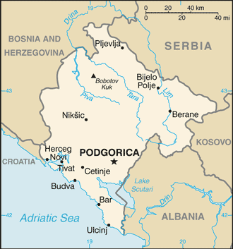
Montenegro’s terrain is typically a highly indented coastline with a narrow coastal plain backed by rugged high limestone mountains and plateaus. The country’s mean elevation: 1,086 m, elevation extremes; lowest point: the Adriatic Sea 0 m, highest point: Bobotov Kuk 2,522 m.
The country’s general climate includes a Mediterranean climate, hot, dry summers and autumns, and relatively cold winters with heavy snowfalls inland.
The total number of border countries is 5, Albania 186 km, Bosnia and Herzegovina 242 km, Croatia 19 km, Kosovo 76 km, Serbia 157 km are the neighboring nations the indicated border lengths. Montenegro’s coastline is 293.5 km, while its marital claims are: territorial sea: 12 nautical miles, continental shelf: defined by treaty. Waterways: N/A. Land use: agricultural land: 38.2%; arable land 12.9%; permanent crops 1.2%; permanent pasture 24.1%; forest: 40.4%; other: 21.4% (2011 estimate).
The population in Montenegro 614,249 (July 2018 estimate), urban population: 64% of total population (2015), major urban area’s population: PODGORICA (capital) 165,000 (2014), while Montenegro has highest population density is concentrated in the south, southwest; the extreme eastern border is the least populated area. Their spoken languages are: Serbian 42.9%, Montenegrin (official language) 37%, Bosnian 5.3%, Albanian 5.3%, Serbo-Croat 2%, other 3.5%, unspecified 4% (2011 estimate). Main religions in Montenegro are Orthodox 72.1%, Muslim 19.1%, Catholic 3.4%, atheist 1.2%, other 1.5%, unspecified 2.6% (2011 estimate). The nation uses civil law. It is a(n) parliamentary republic, National holiday(s) National Day, 13 July (1878, the day the Berlin Congress recognized Montenegro as the 27th independent state in the world, and 1941, the day the Montenegrins staged an uprising against Nazi occupiers and sided with the partisan Communist movement).
Economic overview for the country: Montenegro’s economy is transitioning to a market system. Around 90% of Montenegrin state-owned companies have been privatized, including 100% of banking, telecommunications, and oil distribution. Tourism, which accounts for more than 20% of Montenegro’s GDP, brings in three times as many visitors as Montenegro’s total population every year. Several new luxury tourism complexes are in various development stages along the coast, and a number are being offered in connection with nearby boating and yachting facilities. In addition to tourism, energy and agriculture are considered two distinct pillars of the economy. Only 20% of Montenegro’s hydropower potential is utilized. Montenegro plans to become a net energy exporter, and the construction of an underwater cable to Italy, which will be completed by the end of 2018, will help meet its goal. Montenegro uses the euro as its domestic currency, though it is not an official member of the eurozone. In January 2007, Montenegro joined the World Bank and IMF, and in December 2011, the WTO.
Montenegro began negotiations to join the EU in 2012, having met the conditions set down by the European Council, which called on Montenegro to take steps to fight corruption and organized crime. The government recognizes the need to remove impediments to remain competitive and open the economy to foreign investors. Net foreign direct investment in 2017 reached $848 million, and investment per capita is one of the highest in Europe due to a low corporate tax rate. The most prominent foreign investors in Montenegro in 2017 were Norway, Russia, Italy, Azerbaijan, and Hungary.
Montenegro is currently planning major overhauls of its road and rail networks and possible air transportation system expansions. In 2014, the Government of Montenegro selected two Chinese companies to construct a 41 km-long section of the country’s highway system, which will become part of China’s Belt and Road Initiative. Cheaper borrowing costs have stimulated Montenegro’s growing debt, which currently sits at 65.9% of GDP, with a forecast, absent fiscal consolidation, to increase to 80% once the repayment to China’s Ex/Im Bank of an €800 million highway loan begins in 2019. Montenegro first instituted a value-added tax (VAT) in April 2003 and introduced differentiated VAT rates of 17% and 7% (for tourism) in January 2006. The Montenegrin Government increased the non-tourism Value Added Tax (VAT) rate to 21% as of January 2018 to reduce its public debt.
Natural resources of Montenegro: bauxite, hydroelectricity.
Main export partners for Montenegro, Europe are Croatia 22.7%, Serbia 22.7%, Slovenia 7.8% (2012 estimate) for N/A, while the country’s main import partners are: Serbia 29.3%, Greece 8.7%, China 7.1% (2012 estimate) for N/A.
When you visit this country in Europe, consider the natural hazards in Montenegro: Destructive earthquakes. At the same time, infectious diseases are a degree of risk: intermediate food or waterborne diseases: bacterial diarrhea vectorborne disease: Crimean-Congo hemorrhagic fever (2016). Also, note that Montenegro faces the following environmental issues: Pollution of coastal waters from sewage outlets, especially in tourist-related areas such as Kotor, Serious air pollution in Podgorica, Pljevlja, and Niksie, Air pollution in Pljevlja is caused by the nearby lignite power plant and the domestic use of coal and wood for household heating.
You may also be interested in the countries next to Montenegro around its total: 680 km border, like Albania, Bosnia and Herzegovina, Croatia, Kosovo, Serbia.