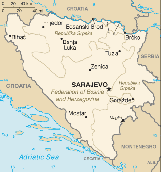
Bosnia and Herzegovina (GPS: 44 00 N, 18 00 E) located in Southeastern Europe, bordering the Adriatic Sea and Croatia. The country’s area measurements are total: 51,197 sq km; land: 51,187 sq km, water: 10 sq km. This sovereign state is slightly smaller than West Virginia. The total irrigated land is 30 sq km (2012).
One of the essential features of Bosnia and Herzegovina: Within Bosnia and Herzegovina’s recognized borders, the country is divided into a joint Bosniak/Croat Federation (about 51% of the territory) and the Bosnian Serb-led Republika Srpska or RS (about 49% of the territory). The region called Herzegovina is contiguous to Croatia and Montenegro. It traditionally has been settled by an ethnic Croat majority in the west and an ethnic Serb majority in the east.
It’s significant, and at the same time, the principal city, Sarajevo’s GPS coordinates are 43 52 N 18 25 E. Sarajevo’s local time is 6 hours ahead of Washington DC during Standard Time. The capital’s time difference: UTC+1, note; Daylight saving time: +1hr begins last Sunday in March; ends last Sunday in October.
Google Maps Bosnia and Herzegovina and Sarajevo, Europe
About Bosnia and Herzegovina in detail
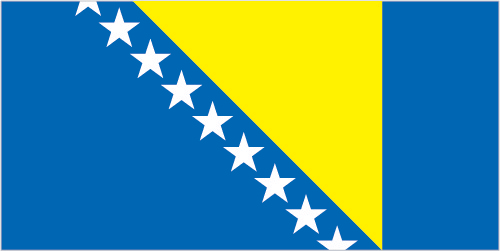
Flag of Bosnia and Herzegovina
Map of Bosnia and Herzegovina
Bosnia and Herzegovina declared sovereignty in October 1991 and independence from the former Yugoslavia on 3 March 1992 after a referendum boycotted by ethnic Serbs. The Bosnian Serbs – supported by neighboring Serbia and Montenegro – responded with armed resistance aimed at partitioning the republic along ethnic lines and joining Serb-held areas to form a “Greater Serbia.” In March 1994, Bosniaks and Croats reduced the number of warring factions from three to two by signing an agreement creating a joint Bosniak-Croat Federation of Bosnia and Herzegovina. On 21 November 1995, in Dayton, Ohio, the warring parties initialed a peace agreement that ended three years of interethnic civil strife (the final agreement was signed in Paris on 14 December 1995). The Dayton Peace Accords retained Bosnia and Herzegovina’s international boundaries and created a multiethnic and democratic government charged with conducting foreign, diplomatic, and fiscal policy.
Also recognized was a second tier of government composed of two entities roughly equal in size: the predominantly Bosniak-Bosnian Croat Federation of Bosnia and Herzegovina and the predominantly Bosnian Serb-led Republika Srpska (RS). The Federation and RS governments are responsible for overseeing most government functions. Additionally, the Dayton Accords established the Office of the High Representative to oversee the implementation of the agreement’s civilian aspects. The Peace Implementation Council at its conference in Bonn in 1997 also gave the High Representative the authority to impose legislation and remove officials, the so-called “Bonn Powers.” An original NATO-led international peacekeeping force (IFOR) of 60,000 troops assembled in 1995 was succeeded over time by a smaller, NATO-led Stabilization Force (SFOR). In 2004, European Union peacekeeping troops (EUFOR) replaced SFOR. Currently, EUFOR deploys around 600 troops in the theater in security assistance and training capacity.
Bosnia and Herzegovina’s names conventional long form: none, traditional short way: Bosnia and Herzegovina, local long form: none, local short form: Bosna i Hercegovina, former: The people’s Republic of Bosnia and Herzegovina, Socialist Republic of Bosnia and Herzegovinaabbreviation: BiH, etymology: the larger northern territory is named for the Bosna River; the smaller southern section takes its name from the German word “herzog,” meaning “duke,” and the ending “-ovina,” meaning “land,” forming the combination denoting “dukedom.” The larger northern territory is named for the Bosna River; The smaller southern section takes its name from the German word “herzog,” meaning “duke,” and the ending “-ovina,” meaning “land,” forming the combination denoting “dukedom.”
Bosnia and Herzegovina’s terrain is typically mountains and valleys. The country’s mean elevation: 500 m, elevation extremes; lowest point: the Adriatic Sea 0 m, highest point: Maglic 2,386 m.
The country’s general climate; hot summers and cold winters: areas of high elevation have short, cool summers and long, severe winters: mild, rainy winters along the coast.
The total number of border countries is 3, Croatia 956 km, Montenegro 242 km, Serbia 345 km are the neighboring nations with the indicated border lengths. Bosnia and Herzegovina’s coastline is 20 km, while its marital claims are: N/A. Waterways: (Sava River on the northern border; open to shipping but use limited) (2011). Land use: agricultural land: 42.2%; arable land 19.7%; permanent crops 2%; permanent pasture 20.5%; forest: 42.8%; other: 15% (2011 estimate).
The population in Bosnia and Herzegovina 3,849,891 (July 2018 estimate), urban population: 39.8% of total population (2015), major urban area’s population: SARAJEVO (capital) 318,000 (2015), while Bosnia and Herzegovina have the northern and central areas of the country are the most densely populated. Their spoken languages are: Bosnian (official language) 52.9%, Serbian (official language) 30.8%, Croatian (official language) 14.6%, other 1.6%, no answer 0.2% (2013 estimate). Main religions in Bosnia and Herzegovina are Muslim 50.7%, Orthodox 30.7%, Roman Catholic 15.2%, atheist 0.8%, agnostic 0.3%, other 1.2%, undeclared/no answer 1.1% (2013 estimate). The nation uses civil law system; Constitutional Court review of legislative acts. It is a(n) parliamentary republic, National holiday(s) National Day (Statehood Day), 25 November (1943); Independence Day, 1 March (1992).
Economic overview for the country: Bosnia and Herzegovina has a transitional economy with limited market reforms. The economy relies heavily on the export of metals, energy, textiles, furniture, remittances, and foreign aid. A highly decentralized government hampers economic policy coordination and reform, while excessive bureaucracy and a segmented market discourage foreign investment. The economy is among the least competitive in the region. Foreign banks, primarily from Austria and Italy, control much of the banking sector, though the largest bank is a private domestic one.
The konvertibilna marka (convertible mark) – the national currency introduced in 1998 – is pegged to the euro through a currency board arrangement, which has maintained confidence in the currency and has facilitated reliable trade links with European partners. Bosnia and Herzegovina became a full member of the Central European Free Trade Agreement in September 2007. In 2016, Bosnia began a three-year IMF loan program, but it has struggled to meet the economic reform benchmarks required to receive all funding installments. Bosnia and Herzegovina’s private sector is growing slowly, but foreign investment dropped sharply after 2007 and remains low. High unemployment remains the most serious macroeconomic problem.
The successful implementation of a value-added tax in 2006 provided a steady source of revenue for the government. It helped rein in gray-market activity, though public perceptions of government corruption and taxpayer money misuse have encouraged a large informal economy to persist. National-level statistics have improved over time, but a large share of economic activity remains unofficial and unrecorded. Bosnia and Herzegovina’s top financial priorities are accelerating integration into the EU, strengthening the fiscal system, public administration reform, World Trade Organization membership; And securing economic growth by fostering a dynamic, competitive private sector.
Natural resources of Bosnia and Herzegovina: coal, iron ore, bauxite, copper, lead, zinc, chromite, cobalt, manganese, nickel, clay, gypsum, salt, sand, timber, hydropower.
Main export partners for Bosnia and Herzegovina, Europe are Slovenia 16.5%, Italy 15.9%, Germany 12.1%, Croatia 11.5%, Austria 11.1%, Turkey 5.2% (2015) for metals, clothing, wood products, while the main import partners for the country are: Croatia 19.3%, Germany 13.9%, Slovenia 13.8%, Italy 10.9%, Austria 5.7%, Hungary 5.2%, Turkey 4.5% (2015) for machinery and equipment, chemicals, fuels, foodstuffs.
When you visit this country in Europe, consider the natural hazards in Bosnia and Herzegovina: Destructive earthquakes, while infectious diseases are N/A. Also, note that Bosnia and Herzegovina face the following environmental issues: Air pollution, deforestation, and illegal logging, Inadequate wastewater treatment, and flood management facilities, Sites for disposing of urban waste are limited, Land mines left over from the 1992-95 civil strife are a hazard in some areas.
You may also be interested in the countries next to Bosnia and Herzegovina around its total: 1,543 km border, like Croatia, Montenegro, Serbia.