Uruguay (GPS: 33 00 S, 56 00 W) located in Southern South America, bordering the South Atlantic Ocean, between Argentina and Brazil. The country’s area measurements are total: 176,215 sq km; land: 175,015 sq km, water: 1,200 sq km. This sovereign state is slightly smaller than the state of Washington. The total irrigated land is 2,380 sq km (2012).
One of the essential features of Uruguay: Second-smallest South American country (after Suriname). Most of the low-lying landscape (three-quarters of the country) is grassland, ideal for cattle and sheep raising.
It’s significant, and simultaneously, the principal city, Montevideo’s GPS coordinates are 34 51 S 56 10 W. Montevideo’s local time is 2 hours ahead of Washington DC during Standard Time. The capital’s time difference: UTC-3.
For more information on Uruguay, please scroll down below the Google Maps.
Google Maps Uruguay and Montevideo, South America
About Uruguay in detail
Flag of Uruguay
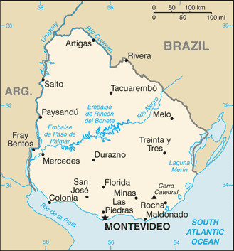
Map of Uruguay
Montevideo, founded by the Spanish in 1726 as a military stronghold, soon took advantage of its natural harbor to become an important commercial center. Claimed by Argentina but annexed by Brazil in 1821, Uruguay declared its independence four years later and secured its freedom in 1828 after a three-year struggle. The administrations of President Jose BATLLE in the early 20th century launched widespread political, social, and economic reforms that established a statist tradition. A violent Marxist urban guerrilla movement named the Tupamaros, launched in the late 1960s, led Uruguay’s president to cede control of the government to the military in 1973.
By yearend, the rebels had been crushed, but the military continued to expand its hold over the government. Civilian rule was restored in 1985. In 2004, the left-of-center Frente Amplio Coalition won national elections that effectively ended 170 years of political control previously held by the Colorado and National (Blanco) parties. Uruguay’s political and labor conditions are among the freest on the continent.
Uruguay’s names conventional long form: the Oriental Republic of Uruguay, traditional short form: Uruguay, local long form: Republica Oriental del Uruguay, local short state: Uruguay, former: Banda Oriental, Cisplatine Province, etymology: the Guarani Indians named the Uruguay River, which makes up the western border of the country and whose name later came to be applied to the entire country. The name derives from the Spanish pronunciation of the Guarani Indian designation of the Uruguay River, which makes up the country’s western border and whose name later came to be applied to the entire country.
Uruguay’s terrain is typically mostly rolling plains and low hills; fertile coastal lowland. The country’s mean elevation: 109 m, elevation extremes; lowest point: Atlantic Ocean 0 m, highest point: Cerro Catedral 514 m.
The general climate in the country; warm temperate: freezing temperatures almost unknown.
The total number of border countries is 2, Argentina 541 km, Brazil 1,050 km are the neighboring nations with the indicated border lengths. Uruguay’s coastline is 660 km. Its marital claims are territorial sea: 12 nautical miles, contiguous zone: 24 nautical miles, exclusive economic zone: 200 nautical miles, continental shelf: 200 nautical miles or the edge of the continental margin. Waterways: 1,600 km (2011). Land use: agricultural land: 87.2%; arable land 10.1%; permanent crops 0.2%; permanent pasture 76.9%; forest: 10.2%; other: 2.6% (2011 estimate).
The population in Uruguay 3,369,299 (July 2018 estimate), urban population: 95.3% of total population (2015), central metropolitan area’s population: MONTEVIDEO (capital) 1.707 million (2015), while Uruguay has most of the country’s population resides in the southern half of the country; approximately 80% of the populace is urban, living in towns or cities; nearly half of the population lives in and around the capital of Montevideo.
Their spoken languages are Spanish (official language), Portunol, Brazilero (Portuguese-Spanish mix on the Brazilian frontier). Main religions in Uruguay are Roman Catholic 47.1%, non-Catholic Christians 11.1%, nondenominational 23.2%, Jewish 0.3%, atheist or agnostic 17.2%, other 1.1% (2006). The nation uses civil law system based on the Spanish civil code. It is a(n) presidential republic, National holiday(s) Independence Day, 25 August (1825).
Economic overview for the country: Uruguay has a free market economy characterized by an export-oriented agricultural sector, a well-educated workforce, and high levels of social spending. Uruguay has sought to expand trade within the Common Market of the South (Mercosur) and non-Mercosur members. President VAZQUEZ has maintained his predecessor’s mix of pro-market policies and a robust social safety net. Following financial difficulties in the late 1990s and early 2000s, Uruguay’s economic growth averaged 8% annually during the 2004-2008 period.
The 2008-2009 global financial crisis put a brake on Uruguay’s vigorous growth, which decelerated to 2.6% in 2009. Nevertheless, the country avoided a recession and kept growth rates positive, mainly through higher public expenditure and investment; GDP growth reached 8.9% in 2010 but slowed markedly in the 2012-2016 period as a result of a renewed slowdown in the global economy and Uruguay’s main trade partners and Mercosur counterparts, Argentina and Brazil. Reforms in those countries should give Uruguay an economic boost. Growth picked up in 2017.
Natural resources of Uruguay: arable land, hydropower, minor minerals, fish.
Main export partners for Uruguay, South America, are China 15%, Brazil 14.4%, US 6.5%, Argentina 4.9% (2015) for beef, soybeans, cellulose, rice, wheat, wood, dairy products; wool, while the main import partners for the country are: Brazil 18.2%, China 17.4%, Argentina 12.6%, US 9.1%, Germany 4.5%, Nigeria 4.1% (2015) for refined oil, crude oil, passenger and other vehicles, vehicle parts, cellular phones.
When you visit this country in South America, consider the natural hazards in Uruguay: Seasonally high winds (the pampero is a chilly and occasional violent wind that blows north from the Argentine pampas), droughts, floods, because of the absence of mountains, which act as weather barriers, all locations are particularly vulnerable to rapid changes from weather fronts, while infectious diseases are N/A. Also, note that Uruguay faces the following environmental issues: Water pollution from the meatpacking/tannery industry, Heavy metal pollution, Inadequate solid/hazardous waste disposal, Deforestation.
You may also be interested in the countries next to Uruguay around its total: 1,591 km border, like Argentina, Brazil.