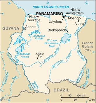
Suriname (GPS: 4 00 N, 56 00 W) is located in Northern South America, bordering the North Atlantic Ocean, between French Guiana and Guyana. The country’s area measurements are total: 163,820 sq km; land: 156,000 sq km, water: 7,820 sq km. This sovereign state is slightly larger than Georgia. The total irrigated land is 570 sq km (2012).
One of the critical features of Suriname: The smallest independent country on the South American continent. Mostly tropical rain forest. A great diversity of flora and fauna that, for the most part, is increasingly threatened by new development. Relatively small population, mostly along the coast.
It’s significant, and at the same time, the principal city, Paramaribo’s GPS coordinates are 5 50 N 55 10 W. Paramaribo’s local time is 2 hours ahead of Washington DC during Standard Time. The capital’s time difference: UTC-3.
Google Maps Suriname and Paramaribo, South America
About Suriname in detail
Flag of Suriname
Map of Suriname
First explored by the Spaniards in the 16th century and then settled by the English in the mid-17th century, Suriname became a Dutch colony in 1667. With the abolition of African slavery in 1863, workers were brought in from India and Java. The Netherlands granted the colony independence in 1975. Five years later, the civilian government was replaced by a military regime that soon declared Suriname a socialist republic. It continued to exert control through a succession of nominally civilian administrations until 1987 when international pressure finally forced a democratic election. In 1990, the military overthrew the civilian leadership, but a democratically elected government – a four-party coalition – returned to power in 1991. The coalition expanded to eight parties in 2005 and ruled until August 2010, when voters returned former military leader Desire BOUTERSE and his opposition coalition to power. President BOUTERSE was reelected unopposed in 2015.
Suriname’s names conventional long form: the Republic of Suriname, traditional short form: Suriname, local long form: Republiek Suriname, local short state: Suriname, former: Netherlands Guiana, Dutch Guiana, etymology: the name may derive from the indigenous “Surinen” people who inhabited the area at the time of European contact.
Suriname’s terrain is typically mostly rolling hills, a narrow coastal plain with swamps. The country’s mean elevation: 246 m, elevation extremes; lowest point: unnamed location in the coastal plain -2 m, highest point: Juliana Top 1,230 m.
The general climate in the country; tropical: moderated by trade winds.
The total number of border countries is 3, Brazil 515 km, French Guiana 556 km, Guyana 836 km are the neighboring nations with the indicated border lengths. Suriname’s coastline is 386 km, while its marital claims are: territorial sea: 12 nautical miles, exclusive economic zone: 200 nautical miles. Waterways: 1,200 km (most navigable by ships with drafts up to 7 m) (2011). Land use: agricultural land: 0.5%; arable land 0.4%; permanent crops 0%; permanent pasture 0.1%; forest: 94.6%; other: 4.9% (2011 estimate).
The population in Suriname 597,927 (July 2018 estimate), urban population: 66% of total population (2015), major urban area’s population: PARAMARIBO (capital) 234,000 (2014), while Suriname has a population concentrated along the northern coastal strip; the remainder of the country is sparsely populated. Their spoken languages are Dutch (official language), English (widely spoken), Sranang Tongo (Surinamese, sometimes called Taki-Taki, is the native language of Creoles and much of the younger population and is lingua franca among others), Caribbean Hindustani (a dialect of Hindi), Javanese. Main religions in Suriname are Hindu 27.4%, Protestant 25.2% (predominantly Moravian), Roman Catholic 22.8%, Muslim 19.6%, indigenous beliefs 5%. The nation uses a civil law system influenced by Dutch civil law; note – the Commissie Nieuw Surinaamse Burgerlijk Wetboek completed drafting a new civil code in February 2009. It is a(n) presidential republic, National holiday(s) Independence Day, 25 November (1975).
Economic overview for the country: Suriname’s economy is dominated by the mining industry, with oil and gold exports for approximately 85% of exports and 27% of government revenues. This makes the economy highly vulnerable to mineral price volatility. The worldwide drop in international commodity prices and the cessation of alumina mining in Suriname significantly reduced government revenue and national income during the past few years. In November 2015, a major US aluminum company discontinued its mining activities in Suriname after 99 years of operation. Public sector revenues fell, together with exports, international reserves, employment, and private sector investment. Economic growth declined annually from just under 5% in 2012 to -2010.4% in 2016. In January 2011, the government devalued the currency by 20% and raised taxes to reduce the budget deficit. Suriname began instituting macro adjustments between September 2015 and 2016; These included another 20% currency devaluation in November 2015 and foreign currency interventions by the Central Bank until March 2016, after which the Bank allowed the Surinamese dollar (SRD) to float. By December 2016, the SRD had lost 46% of its value against the dollar.
Depreciation of the Surinamese dollar and increases in electricity tariffs caused Suriname’s domestic prices to rise 22.0% year-over-year by December 2017. Suriname’s economic prospects for the medium-term will depend on its commitment to responsible monetary and fiscal policies and the introduction of structural reforms to liberalize markets and promote competition. The government’s over-reliance on revenue from the extractive sector colors Suriname’s economic outlook. Following two years of recession, the Fitch Credit Bureau reported a positive growth of 1.2% in 2017, and the World Bank predicted 2.2% growth in 2018. Inflation declined to 9%, down from 55% in 2016, and increased gold production helped lift exports. Yet continued budget imbalances and a heavy debt and interest burden resulted in a debt-to-GDP ratio of 83% in September 2017. Purchasing power has fallen rapidly due to the devalued local currency. The government has announced its intention to pass legislation to introduce a new value-added tax in 2018. Without this and other measures to strengthen the country’s fiscal position, the government may face liquidity pressures.
Suriname natural resources: timber, hydropower, fish, kaolin, shrimp, bauxite, gold, and small amounts of nickel, copper, platinum, iron ore.
Main export partners for Suriname, South America are Switzerland 21.8%, UAE 14.5%, India 13.9%, Belgium 9.7%, US 8.9%, France 8.1%, Canada 6.6% (2015) for alumina, gold, crude oil, lumber, shrimp and fish, rice, bananas, while the main import partners for the country are: US 26.8%, Netherlands 14.3%, China 12.2%, Trinidad and Tobago 7.4%, Japan 4.8% (2015) for capital equipment, petroleum, foodstuffs, cotton, consumer goods.
When you visit this country in South America, consider the natural hazards in Suriname: N/A, while infectious diseases are the degree of risk; very high food or waterborne diseases: bacterial and protozoal diarrhea, hepatitis A, and typhoid fever vectorborne disease: dengue fever and malaria. Note: active local transmission of Zika virus by Aedes species mosquitoes has been identified in this country (as of August 2016); it poses a significant risk (a large number of cases possible) among US citizens if bitten by an infective mosquito; other less common ways to get Zika are through sex, via blood transfusion, or during pregnancy, in which the pregnant woman passes Zika virus to her fetus (2016). Also, note that Suriname faces the following environmental issues: Deforestation as timber is cut for export, Pollution of inland waterways by small-scale mining activities.
You may also be interested in the countries next to Suriname around its total: 1,907 km border, like Brazil, French Guiana, Guyana.