Guyana (GPS: 5 00 N, 59 00 W) is located in Northern South America, bordering the North Atlantic Ocean, between Suriname and Venezuela. The country’s area measurements are total: 214,969 sq km; land: 196,849 sq km, water: 18,120 sq km. This sovereign state is slightly smaller than Idaho. The total irrigated land is 1,430 sq km (2012).
One of the crucial features of Guyana: The third-smallest country in South America after Suriname and Uruguay. Venezuela and Suriname, respectively, claim substantial portions of its western and eastern territories. Contains some of the largest unspoiled rainforests on the continent.
It’s significant, and at the same time, the principal city, Georgetown’s GPS coordinates are 6 48 N 58 09 W. Georgetown’s local time is 1 hour ahead of Washington DC during Standard Time. The capital’s time difference: UTC-4.
For more information on Guyana, please scroll down below the Google Maps.
Google Maps Guyana and Georgetown, South America
About Guyana in detail
Flag of Guyana
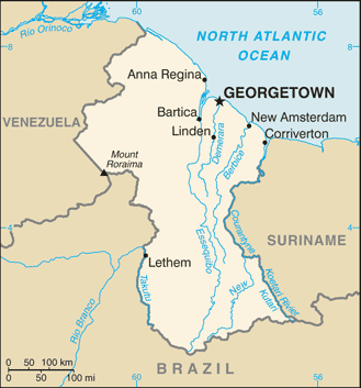
Map of Guyana
Originally a Dutch colony in the 17th century, by 1815, Guyana had become a British possession. The abolition of slavery led to urban areas’ settlement by former slaves and importing indentured servants from India to work the sugar plantations. The resulting ethnocultural divide has persisted and has led to turbulent politics. Guyana achieved independence from the UK in 1966; it has been ruled mostly by socialist-oriented governments.
In 1992, Cheddi JAGAN was elected president in its first free and fair election since independence. After his death five years later, his wife, Janet JAGAN, became president but resigned in 1999 due to poor health. Her successor, Bharrat JAGDEO, was elected in 2001 and again in 2006. Early elections held in May 2015 resulted in the first change in the governing party and the replacement of President Donald RAMOTAR by current President David GRANGER. After a December 2018 no-confidence vote against the GRANGER government, national elections will be held before the scheduled spring 2020 date.
Guyana’s names conventional long form: the Cooperative Republic of Guyana, traditional short form: Guyana, former: British Guiana, etymology: the name is derived from Guiana, the original name for the region that included British Guiana, Dutch Guiana, and French Guiana; ultimately the word is derived from an indigenous Amerindian language and means “land of many waters” (referring to the area’s multitude of rivers and streams). The name is derived from Guiana, the original name for the region that included British Guiana, Dutch Guiana, and French Guiana; ultimately, the word is derived from an indigenous Amerindian language and means “Land of Many Waters” (referring to the area’s multitude of rivers and streams).
Guyana’s terrain is typically mostly rolling highlands; low coastal plain; savanna in the south. The country’s mean elevation: 207 m, elevation extremes; lowest point: Atlantic Ocean 0 m, highest point: Mount Roraima 2,835 m.
The country’s general climate is tropical: hot, humid, moderated by northeast trade winds: two rainy seasons (May to August, November to January).
The total number of border countries is 3, Brazil 1,308 km, Suriname 836 km, Venezuela 789 km are the neighboring nations with the indicated border lengths. Guyana’s coastline is 459 km. Its marital claims are territorial sea: 12 nautical miles, exclusive economic zone: 200 nautical miles, continental shelf: 200 nautical miles or to the outer edge of the continental margin. Waterways: 330 km (the Berbice, Demerara, and Essequibo Rivers are navigable by oceangoing vessels for 150 km, 100 km, and 80 km respectively) (2012). Land use: agricultural land: 8.4%; arable land 2.1%; permanent crops 0.1%; permanent pasture 6.2%; forest: 77.4%; other: 14.2% (2011 estimate).
The population in Guyana 740,685 (July 2018 estimate), urban population: 28.6% of total population (2015), major urban area’s population: GEORGETOWN (capital) 124,000 (2014), while Guyana has a population is heavily concentrated in the northeast in and around Georgetown, with notable concentrations along the Berbice River to the east; the remainder of the country is sparsely populated.
Their spoken languages are English (official language), Guyanese Creole, Amerindian languages (including Caribbean and Arawak languages), Indian languages (including Caribbean Hindustani, a dialect of Hindi), Chinese (2014 estimate). Main religions in Guyana are Protestant 30.5% (Pentecostal 16.9%, Anglican 6.9%, Seventh Day Adventist 5%, Methodist 1.7%), Hindu 28.4%, Roman Catholic 8.1%, Muslim 7.2%, Jehovah’s Witness 1.1%, other Christian 17.7%, other 1.9%, none 4.3%, unspecified 0.9% (2002 estimate). The nation uses a common law system, based on the English model, with some Roman-Dutch civil law influence. It is a(n) parliamentary republic, National holiday(s) Republic Day, 23 February (1970).
Economic overview for the country: The Guyanese economy exhibited moderate economic growth in recent years and is based mainly on agriculture and extractive industries. The economy is heavily dependent upon the export of six commodities – sugar, gold, bauxite, shrimp, timber, and rice – representing nearly 60% of its GDP. It is highly susceptible to adverse weather conditions and fluctuations in commodity prices. Guyana closed or consolidated several sugar estates in 2017, reducing sugar production to a forecasted 147,000 tons in 2018, less than half of 2017 production.
Much of Guyana’s growth in recent years has come from a surge in gold production. With a record-breaking 700,000 ounces of gold produced in 2016, Gold production in Guyana has offset declining sugar production’s economic effects. In January 2018, an estimated 3.2 billion barrels of oil were found offshore, and Guyana is scheduled to become a petroleum producer by March 2020. Guyana’s entrance into the Caricom Single Market and Economic in January 2006 broadened its export market, primarily in the raw materials sector. Guyana has experienced positive growth almost every year over the past decade. Inflation has been kept under control. Recent years have seen the government’s stock of debt reduced significantly – with external debt now less than half of what it was in the early 1990s. Despite these improvements, the government is still juggling a sizable external debt against the urgent need for expanded public investment.
In March 2007, the Inter-American Development Bank, Guyana’s principal donor, canceled Guyana’s nearly $470 million debt, equivalent to 21% of GDP, which along with other Highly Indebted Poor Country debt forgiveness, brought the debt-to-GDP ratio down from 183% in 2006 to 52% in 2017. Guyana had become heavily indebted due to the inward-looking, state-led development model pursued in the 1970s and 1980s. Chronic problems include a shortage of skilled labor and a deficient infrastructure.
Main export partners for Guyana, South America, are US 33.5%, Canada 17.9%, UK 6.7%, Ukraine 4.3%, Jamaica 4% (2015) for sugar, gold, bauxite, alumina, rice, shrimp, molasses, rum, timber, while the main import partners for the country are: the US 24.6%, Trinidad and Tobago 24.1%, China 10.8%, Suriname 9.5% (2015) for manufactures, machinery, petroleum, food.
When you visit this country in South America, consider the natural hazards in Guyana: Flash flood threat during rainy seasons, while infectious diseases are a degree of risk: very high food or waterborne diseases: bacterial and protozoal diarrhea, hepatitis A, and typhoid fever vectorborne diseases: dengue fever and malaria. Note: active local transmission of Zika virus by Aedes species mosquitoes has been identified in this country (as of August 2016); it poses a significant risk (a large number of cases possible) among US citizens if bitten by an infective mosquito; other less common ways to get Zika are through sex, via blood transfusion, or during pregnancy, in which the pregnant woman passes Zika virus to her fetus (2016). Also, note that Guyana faces the following environmental issues: Water pollution from sewage and agricultural and industrial chemicals, Deforestation.
You may also be interested in the countries next to Guyana around its total: 2,933 km border, like Brazil, Suriname, Venezuela.