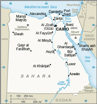
Egypt (GPS: 27 00 N, 30 00 E) located in Northern Africa, bordering the Mediterranean Sea, between Libya and the Gaza Strip, and the Red Sea north of Sudan, including the Asian Sinai Peninsula. The country’s area measurements are total: 1,001,450 sq km; land: 995,450 sq km, water: 6,000 sq km. This sovereign state is more than eight times the size of Ohio, slightly more than three times the size of New Mexico. The total irrigated land is 36,500 sq km (2012).
One of Egypt’s important features: Controls the Sinai Peninsula, the only land bridge between Africa and the remainder of the Eastern Hemisphere. Controls Suez Canal, a sea link between the Indian Ocean and the Mediterranean Sea. Size, and juxtaposition to Israel, establish its significant role in Middle Eastern geopolitics. Dependence on upstream neighbors. The dominance of Nile basin issues. Prone to influxes of refugees from Sudan and the Palestinian territories.
It’s significant, and at the same time, the principal city, Cairo’s GPS coordinates are 30 03 N 31 15 E. Cairo’s local time is 7 hours ahead of Washington DC during Standard Time. The capital’s time difference: UTC+2.
For more information on Egypt, please scroll down below the Google Maps.
Google Maps Egypt and Cairo, Africa
About Egypt in detail
Flag of Egypt
Map of Egypt
The regularity and richness of the annual Nile River flood, coupled with semi-isolation provided by deserts to the east and west, allowed for the development of one of the world’s great civilizations. A unified kingdom arose circa 3200 B.C., and a series of dynasties ruled in Egypt for the next three millennia. The last native dynasty fell to the Persians in 341 B.C., who was replaced by the Greeks, Romans, and Byzantines. The Arabs introduced Islam and the Arabic language in the 7th century and ruled for the next six centuries. A local military caste, the Mamluks took control of about 1250 and continued to govern after Egypt’s conquest by the Ottoman Turks in 1517. Completion of the Suez Canal in 1869 elevated Egypt as an important world transportation hub. Ostensibly to protect its investments, Britain seized Egypt’s government in 1882, but nominal allegiance to the Ottoman Empire continued until 1914. Partially independent from the UK in 1922, Egypt acquired full sovereignty from Britain in 1952.
The completion of the Aswan High Dam in 1971 and the resultant Lake Nasser have reaffirmed the Nile River’s time-honored place in the agriculture and ecology of Egypt. A rapidly growing population (the largest in the Arab world), limited arable land, and dependence on the Nile all continue to overtax resources and stress society. The government has struggled to meet the demands of Egypt’s fast-growing population as it implements far-reaching economic reforms, including the reduction of special subsidies, large-scale infrastructure projects, energy cooperation, and foreign direct investment appeals. Inspired by the 2010 Tunisian revolution, Egyptian opposition groups led demonstrations and labor strikes countrywide, culminating in President Hosni MUBARAK’s ouster in 2011.
Egypt’s military assumed national leadership until a new legislature was in place in early 2012; Later that same year, Muhammad MURSI won the presidential election. Following protests throughout the spring of 2013 against MURSI’s government and the Muslim Brotherhood, the Egyptian Armed Forces intervened and removed MURSI from power in July 2013 and replaced him with interim president Adly MANSOUR. Simultaneously, the government began enacting laws to limit freedoms of assembly and expression. In January 2014, voters approved a new constitution by referendum, and in May 2014, elected former defense minister Abdelfattah ELSISI president. Egypt elected a new legislature in December 2015, its first Hose of Representatives since 2012. ELSISI was reelected to a second four-year term in March 2018. In April 2019, Egypt approved via national referendum a set of constitutional amendments extending ELSISI’s time in office through 2024 and possibly through 2030 if re-elected for a third term. The amendments would also allow future presidents up to two consecutive six-year terms in office, re-establish an upper legislative house, allow for one or more vice presidents, establish a 25% quota for female legislators, reaffirm the military’s role as guardian of Egypt, and expand presidential authority to appoint the heads of judicial councils.
Egypt’s names conventional long form: the Arab Republic of Egypt, conventional short form: Egypt, local long form: Jumhuriyat Misr al-Arabiyah, local short form: Misr, former: United Arab Republic (with Syria), etymology: the English name “Egypt” derives from the ancient Greek name for the country “Aigyptos”; the Arabic name “Misr” can be traced to the ancient Akkadian “misru” meaning border or frontier. The English name “Egypt” derives from the ancient Greek name for the country “Aigyptos”; The Arabic name “Misr” can be traced to the ancient Akkadian “misru” meaning border or frontier.
Egypt’s terrain is typically a vast desert plateau interrupted by Nile valley and delta. The country’s mean elevation: 321 m, elevation extremes; lowest point: Qattara Depression -133 m, highest point: Mount Catherine 2,629 m.
The general climate in the country; desert: hot, dry summers with moderate winters.
The total number of border countries is 4, Gaza Strip 13 km, Israel 208 km, Libya 1,115 km, Sudan 1,276 km are the neighboring nations with the indicated border lengths. Egypt’s coastline is 2,450 km. Its marital claims are territorial sea: 12 nautical miles, contiguous zone: 24 nautical miles, exclusive economic zone: 200 nautical miles, or the central median line with Cypruscontinental shelf: 200 nautical miles. Waterways: 3,500 km (includes the Nile River, Lake Nasser, Alexandria-Cairo Waterway, and numerous smaller canals in Nile Delta; the Suez Canal (193.5 km including approaches) is navigable by oceangoing vessels drawing up to 17.68 m) (2011). Land use: agricultural land: 3.6%; arable land 2.8%; permanent crops 0.8%; permanent pasture 0%; forest: 0.1%; other: 96.3% (2011 estimate).
The population in Egypt 99,413,317 (July 2018 estimate), urban population: 43.1% of total population (2015), major urban area’s population: CAIRO (capital) 18.772 million; Alexandria 4.778 million (2015), while Egypt has approximately 95% of the population lives within 20 km of the Nile River and its delta; vast areas of the country remain sparsely populated or uninhabited. Their spoken languages are Arabic (official language), English, and French, widely understood by educated classes. Main religions in Egypt are Muslim (predominantly Sunni) 90%, Christian (majority Coptic Orthodox, other Christians include Armenian Apostolic, Catholic, Maronite, Orthodox, and Anglican) 10% (2012 estimate). The nation uses mixed legal system based on Napoleonic civil and penal law, Islamic religious law, and vestiges of colonial-era laws; judicial review of the constitutionality of laws by the Supreme Constitutional Court. It is a(n) presidential republic, National holiday(s) Revolution Day, 23 July (1952).
Economic overview for the country: Occupying the northeast corner of the African continent, Egypt is bisected by the highly fertile Nile valley where most economic activity takes place. Egypt’s economy was highly centralized during the rule of former President Gamal Abdel NASSER but opened up considerably under former Presidents Anwar EL-SADAT and Mohamed Hosni MUBARAK. Agriculture, hydrocarbons, manufacturing, tourism, and other service sectors drove the country’s relatively diverse economic activity.
Despite Egypt’s mixed record for attracting foreign investment over the past two decades, poor living conditions and limited job opportunities have contributed to public discontent. These socioeconomic pressures were a significant factor leading to the January 2011 revolution that ousted MUBARAK. The uncertain political, security, and policy environment since 2011 has restricted economic growth and failed to alleviate persistent unemployment, especially among the young. In late 2016, ongoing dollar shortages and waning aid from its Gulf allies led Cairo to turn to the IMF for a 3-year, $12 billion loan program. To secure the deal, Cairo floated its currency, introduced new taxes, and cut energy subsidies – all of which pushed inflation above 30% for most of 2017, a high that had not been seen in a generation. Since the currency float, foreign investment in Egypt’s high-interest treasury bills has risen exponentially, boosting both dollar availability and central bank reserves. Cairo will be challenged to obtain foreign and local investment in manufacturing and other sectors without a sustained effort to implement a range of business reforms.
Natural resources of Egypt: petroleum, natural gas, iron ore, phosphates, manganese, limestone, gypsum, talc, asbestos, lead, rare earth elements, zinc.
Main export partners for Egypt, Africa are Saudi Arabia 9.1%, Italy 7.5%, Turkey 5.8%, UAE 5.1%, US 5.1%, UK 4.4%, India 4.1% (2015) for crude oil and petroleum products, fruits and vegetables, cotton, textiles, metal products, chemicals, processed food, while the main import partners for the country are: China 13%, Germany 7.7%, US 5.9%, Turkey 4.5%, Russia 4.4%, Italy 4.4%, Saudi Arabia 4.1% (2015) for machinery and equipment, foodstuffs, chemicals, wood products, fuels.
When you visit this country in Africa, consider the natural hazards in Egypt: Periodic droughts, frequent earthquakes, flash floods, landslides, hot, driving windstorms called khamsin occur in spring, dust storms, sandstorms, while infectious diseases are a degree of risk: intermediate food or waterborne diseases: bacterial diarrhea, hepatitis A, and typhoid fever water contact disease: schistosomiasis (2016). Also, note that Egypt faces the following environmental issues: Agricultural land being lost to urbanization and windblown sands, Increasing soil salination below Aswan High Dam, Desertification, Oil pollution threatening coral reefs, beaches, and marine habitats, Other water pollution from agricultural pesticides, raw sewage, and industrial effluents, Limited natural freshwater resources away from the Nile, which is the only perennial water source, Rapid growth in population overstraining the Nile and natural resources.
You may also be interested in the countries next to Egypt around its total: 2,612 km border, like the Gaza Strip, Israel, Libya, Sudan.