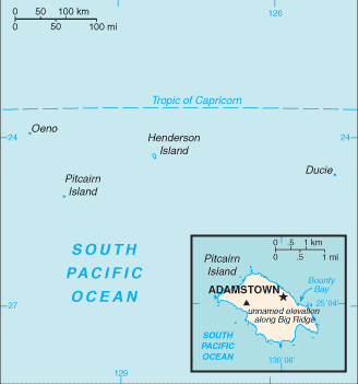
Pitcairn Islands (GPS: 25 04 S, 130 06 W) is located in Oceania, islands in the South Pacific Ocean, midway between Peru and New Zealand. The country’s area measurements are total: 47 sq km; land: 47 sq km, water: 0 sq km. This sovereign state is about three-tenths the size of Washington, DC. The total irrigated land is 0 sq km (2012).
One of the critical features of the Pitcairn Islands: Britain’s most isolated dependency. Only the larger island of Pitcairn is inhabited, but it has no port or natural harbor. Supplies must be transported by rowed longboat from larger ships stationed offshore.
It’s significant, and at the same time, the principal city, Adamstown’s GPS coordinates are 25 04 S 130 05 W. Adamstown’s local time is 4 hours behind Washington DC during Standard Time. The capital’s time difference: UTC-9.
Google Maps Pitcairn Islands and Adamstown, Oceania
About the Pitcairn Islands in detail
Flag of Pitcairn Islands
Map of Pitcairn Islands
Pitcairn Island was discovered in 1767 by the British and settled in 1790 by the Bounty mutineers and their Tahitian companions. Pitcairn was the first Pacific island to become a British colony (in 1838) and today remains the last vestige of that empire in the South Pacific. Outmigration, primarily to New Zealand, has thinned the population from a peak of 233 in 1937 to less than 50 today.
Pitcairn Islands’s names conventional long form: Pitcairn, Henderson, Ducie, and Oeno Islands, conventional short form: the Pitcairn Islands, etymology: named after Midshipman Robert PITCAIRN who first sighted the island in 1767.
Pitcairn Islands’s terrain is typically rugged volcanic formation, rocky coastline with cliffs. The country’s mean elevation: N/A, elevation extremes; lowest point: Pacific Ocean 0 m, highest point: Big Ridge 347 m.
The country’s general climate is tropical: hot and humid: modified by southeast trade winds: rainy season (November to March).
The total number of border countries is 0; none are the neighboring nations with the indicated border lengths. Pitcairn Islands’s coastline is 51 km, while its marital claims are: territorial sea: 3 nautical miles, exclusive economic zone: 200 nautical miles. Waterways: N/A. Land use: agricultural land: 0%; arable land 0%; permanent crops 0%; permanent pasture 0%; forest: 74.5%; other: 25.5% (2011 estimate).
The population in Pitcairn Islands 54 (July 2016 estimate), urban population: 0% of total population (2012), central urban area’s population: N/A, while Pitcairn Islands has N/A. Their spoken languages are English (official language), Pitkern (a mixture of an 18th-century English dialect and a Tahitian dialect). The main religions in the Pitcairn Islands are Seventh-Day Adventist 100%. The nation uses local island by-laws. It is a(n) parliamentary democracy (Island Council); overseas territory of the UK, National holiday(s) Birthday of Queen ELIZABETH II, second Saturday in June (1926); Discovery Day, 2 July (1767).
Economic overview for the country: The inhabitants of this tiny isolated economy exist on fishing, subsistence farming, handicrafts, and postage stamps. The valleys’ fertile soil produces a wide variety of fruits and vegetables, including citrus, sugarcane, watermelons, bananas, yams, and beans. Bartering is an essential part of the economy. The primary revenue sources are selling postage stamps to collectors and the sale of handicrafts to passing ships.
Natural resources of Pitcairn Islands: miro trees (used for handicrafts), fish. Note: manganese, iron, copper, gold, silver, and zinc have been discovered offshore.
Main export partners for the Pitcairn Islands, Oceania are N/A for fruits, vegetables, curios, postage stamps, while the main import partners for the country are: N/A for fuel oil, machinery, building materials, flour, sugar, other foodstuffs.
When you visit this country in Oceania, consider the Pitcairn Islands’ natural hazards: Typhoons (especially November to March), while infectious diseases are N/A. Also, note that the Pitcairn Islands faces the following environmental issues: Deforestation (only a small portion of the original forest remains because of burning and clearing for settlement).
You may also be interested in the countries next to the Pitcairn Islands around its 0 km border – No border countries.