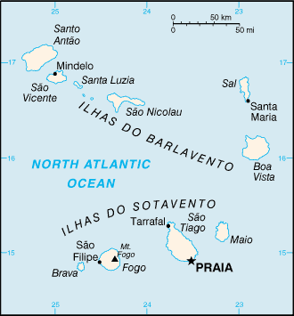
Cabo Verde (GPS: 16 00 N, 24 00 W) is located in Western Africa, a group of islands in the North Atlantic Ocean, west of Senegal. The country’s area measurements are total: 4,033 sq km; land: 4,033 sq km, water: 0 sq km. This sovereign state is slightly larger than Rhode Island. The total irrigated land is 35 sq km (2012).
One of the important features of Cabo Verde: Strategic location 500 km from the west coast of Africa near major north-south sea routes. Important communications station. Important sea and air refueling site.
It’s significant, and at the same time, the principal city, Praia’s GPS coordinates are 14 55 N 23 31 W. Praia’s local time is 4 hours ahead of Washington DC during Standard Time. The capital’s time difference: UTC-1.
The uninhabited islands were discovered and colonized by the Portuguese in the 15th century; Cabo Verde subsequently became a trading center for African slaves and later an important coaling and resupply stop for whaling and transatlantic shipping. The fusing of European and various African cultural traditions is reflected in Cabo Verde’s Krioulo language, music, and pano textiles. Following independence in 1975 and a tentative interest in unification with Guinea-Bissau, a one-party system was established and maintained until multi-party elections were held in 1990. Cabo Verde continues to sustain one of Africa’s most stable democratic governments and one of its most stable economies, maintaining a currency formerly pegged to the Portuguese escudo and then the euro since 1998. Repeated droughts during the second half of the 20th century caused significant hardship and prompted heavy emigration. As a result, Cabo Verde’s expatriate population – concentrated in Boston and Western Europe – is greater than its domestic one.
Most Cabo Verdeans have both African and Portuguese antecedents. Cabo Verde’s population descends from its first permanent inhabitants in the late 15th-century – a preponderance of West African slaves, a small share of Portuguese colonists, and even fewer Italians, Spaniards, and Portuguese Jews. Among the nine inhabited islands, population distribution is variable. Islands in the east are arid and are home to the country’s growing tourism industry. The more western islands receive more precipitation and support larger populations, but agriculture and livestock grazing have damaged their soil fertility and vegetation. For centuries, the country’s overall population size has fluctuated significantly, as recurring periods of famine and epidemics have caused high death tolls and emigration.
Cabo Verde’s names conventional long form: the Republic of Cabo Verde, conventional short form: Cabo Verde, local long form: Republica de Cabo Verde, local short form: Cabo Verde, etymology: the name derives from Cap-Vert (Green Cape) on the Senegalese coast, the westernmost point of Africa and the nearest mainland to the islands.
Cabo Verde’s terrain is typically steep, rugged, rocky, volcanic. The country’s mean elevation: N/A, elevation extremes; lowest point: Atlantic Ocean 0 m, highest point: Mt. Fogo 2,829 m.
The general climate in the country; temperate: warm, dry summer: precipitation meager and erratic.
The total number of border countries is 0; none are the neighboring nations with the indicated border lengths. Cabo Verde’s coastline is 965 km, while its marital claims are: measured from claimed archipelagic baselines territorial sea: 12 nautical miles, contiguous zone: 24 nautical miles, exclusive economic zone: 200 nautical miles. Waterways: N/A. Land use: agricultural land: 18.6%; arable land 11.7%; permanent crops 0.7%; permanent pasture 6.2%; forest: 21%; other: 60.4% (2011 estimate).
The population in Cabo Verde 568,373 (July 2018 estimate), urban population: 65.5% of total population (2015), major urban area’s population: PRAIA (capital) 145,000 (2014), while Cabo Verde has Among the nine inhabited islands, population distribution is variable. Islands in the east are arid and are only sparsely settled to exploit their extensive salt deposits. The more southerly islands receive more precipitation and support larger populations, but agriculture and livestock grazing have damaged the soil fertility and vegetation. Their spoken languages are Portuguese (official language), Crioulo (a blend of Portuguese and West African words). Main religions in Cabo Verde are Roman Catholic 77.3%, Protestant 4.6% (includes Church of the Nazarene 1.7%, Adventist 1.5%, Assembly of God 0.9%, Universal Kingdom of God 0.4%, and God and Love 0.1%), other Christian 3.4% (includes Christian Rationalism 1.9%, Jehovah’s Witness 1%, and New Apostolic 0.5%), Muslim 1.8%, other 1.3%, none 10.8%, unspecified 0.7% (2010 estimate). The nation uses the civil law system of Portugal. It is a(n) parliamentary republic, National holiday(s) Independence Day, 5 July (1975).
Economic overview for the country: Cabo Verde’s economy depends on development aid, foreign investment, remittances, and tourism. The economy is service-oriented, with commerce, transport, tourism, and public services accounting for about three-fourths of GDP. Tourism is the mainstay of the economy and depends on conditions in the euro-zone countries. Cabo Verde annually runs a high trade deficit financed by foreign aid and remittances from its large pool of emigrants; remittances as a share of GDP are most elevated in Sub-Saharan Africa. Although about 40% of the population lives in rural areas, the percentage of food production in GDP is low. The island economy suffers from a poor natural resource base, including severe water shortages, exacerbated by cycles of long-term drought, and poor soil for growing food on several islands, requiring importing most of what it consumes. The fishing potential, mostly lobster and tuna, is not fully exploited. Economic reforms aim to develop the private sector and attract foreign investment to diversify the economy and mitigate high unemployment. The government’s elevated debt levels have limited its capacity to finance any shortfalls.
Natural resources of Cabo Verde: salt, basalt rock, limestone, kaolin, fish, clay, gypsum.
Main export partners for Cabo Verde, Africa are Australia 83%, Spain 8.6% (2015) for fuel (re-exports), shoes, garments, fish, hides, while the main import partners for the country are: Portugal 29.9%, Australia 26.4%, Netherlands 11.2%, Spain 5.6%, China 5.6% (2015) for foodstuffs, industrial products, transport equipment, fuels.
When you visit this country in Africa, consider the natural hazards in Cabo Verde: Prolonged droughts, seasonal harmattan wind produces obscuring dust, volcanically and seismically active. Volcanism: Fogo (elevation 2,829 m), which last erupted in 1995, is Cabo Verde’s only active volcano, while infectious diseases are noted: active local transmission of Zika virus by Aedes species mosquitoes have been identified in this country (as of August 2016); it poses a significant risk (a large number of cases possible) among US citizens if bitten by an infective mosquito; other less common ways to get Zika are through sex, via blood transfusion, or during pregnancy, in which the pregnant woman passes Zika virus to her fetus (2016). Also, note that Cabo Verde faces the following environmental issues: Deforestation due to demand for firewood, water shortages, Prolonged droughts, and improper use of land (overgrazing, crop cultivation on hillsides lead to desertification and erosion). Environmental damage has threatened several species of birds and reptiles, Illegal beach sand extraction, overfishing.
You may also be interested in the countries next to Cabo Verde around its 0 km border – No border countries.